Geolocate

Farmington topographic map

Click on the map to display elevation.

About this map

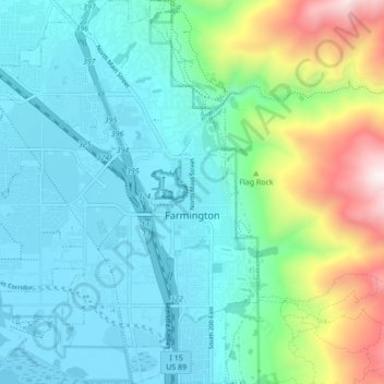
Name: Farmington topographic map, elevation, terrain.

Location: Farmington, Davis County, Utah, United States (40.95211 -111.94692 41.01653 -111.87293)

Average elevation: 1,553 m

Minimum elevation: 1,280 m

Maximum elevation: 2,507 m

Other topographic maps

Click on a map to view its topography, its elevation and its terrain.

Antelope Island

United States > Utah > Davis County

The island is accessible via a 7-mile causeway from Syracuse in Davis County. Access from Interstate 15 is via exit 332, then west along Antelope Drive (SR-108). The island's shore (all but west side of the island) is mostly flat with beaches and plains to the base of the mountains on the island. These steep…

Average elevation: 1,306 m

Florece

United States > Utah > Davis County > Centerville

Average elevation: 1,378 m

Hight

United States > Utah > Davis County > Farmington

Average elevation: 1,463 m

Lakeview Hills

United States > Utah > Davis County > Farmington

Average elevation: 1,523 m

Stoney Brook

United States > Utah > Davis County > Farmington

Average elevation: 1,493 m

Farmington Station

United States > Utah > Davis County > Farmington

Average elevation: 1,467 m

Farmington

United States > Utah > Davis County > Farmington > Farmington

Average elevation: 1,595 m

Gear up for your next adventure:

🗺️Topographic Maps - Detailed maps to explore trails, mountains, and wilderness areas
📷Outdoor Action Camera - Capture high-elevation views and rugged adventures
🐕Hiking Dog Pack - Let your canine companion carry their own water and food
🛁Quick-Dry Microfiber Towel - Space-saving towel that dries rapidly on the move
🥾Trekking Boots - Durable boots for long-distance trekking

As an Amazon Associate, this site earns from qualifying purchases at no extra cost to you.