
Make a donation
Gear up for your next adventure:
As an Amazon Associate, this site earns from qualifying purchases at no extra cost to you.
Herrstein topographic map
Click on the map to display elevation.
Make a donation
Gear up for your next adventure:
As an Amazon Associate, this site earns from qualifying purchases at no extra cost to you.
About this map
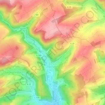
Name: Herrstein topographic map, elevation, terrain.
Average elevation: 386 m
Minimum elevation: 293 m
Maximum elevation: 458 m
Make a donation
Gear up for your next adventure:
As an Amazon Associate, this site earns from qualifying purchases at no extra cost to you.
Other topographic maps
Click on a map to view its topography, its elevation and its terrain.
Eschelbacherhof
Deutschland > Rheinland-Pfalz > Landkreis Birkenfeld > Baumholder
Average elevation: 485 m
Burg Birkenfeld
Deutschland > Rheinland-Pfalz > Landkreis Birkenfeld > Birkenfeld
Im 13. Jahrhundert kam es zu Auseinandersetzungen zwischen den Erzbischöfen von Trier und den Grafen von Sponheim, die in der ersten Hälfte des 14. Jahrhunderts ihren Höhepunkt erreichten. In diese Zeit fällt auch die erste Erwähnung der Burg Birkenfeld in einer Urkunde vom 26. Februar 1293.
Average elevation: 412 m
Kirchenbollenbach
Deutschland > Rheinland-Pfalz > Landkreis Birkenfeld > Idar-Oberstein
Average elevation: 425 m
Make a donation
Gear up for your next adventure:
As an Amazon Associate, this site earns from qualifying purchases at no extra cost to you.
Mittelbollenbach
Deutschland > Rheinland-Pfalz > Landkreis Birkenfeld > Idar-Oberstein
Average elevation: 399 m
Georg-Weierbach
Deutschland > Rheinland-Pfalz > Landkreis Birkenfeld > Idar-Oberstein
Average elevation: 305 m
Idarkopf
Deutschland > Rheinland-Pfalz > Landkreis Birkenfeld > Weitersbach
Etwa 200 m nordwestlich vom Gipfel des Idarkopfs steht auf 744,2 m Höhe der Aussichtsturm Idarkopfturm, von dem der Blick zum Beispiel zum Taunus, zum Donnersberg über den Hunsrück, zur Eifel und zum Westerwald fällt. Rund 300 m nordöstlich des Gipfels steht auf etwa 738 m Höhe ein Sendeturm.
Average elevation: 620 m
Make a donation
Gear up for your next adventure:
As an Amazon Associate, this site earns from qualifying purchases at no extra cost to you.
Nahbollenbach
Deutschland > Rheinland-Pfalz > Landkreis Birkenfeld > Idar-Oberstein
Average elevation: 332 m
Weierbach
Deutschland > Rheinland-Pfalz > Landkreis Birkenfeld > Idar-Oberstein > Weierbach
Average elevation: 305 m
Einschiederhof
Deutschland > Rheinland-Pfalz > Landkreis Birkenfeld > Börfink
Average elevation: 602 m
Make a donation
Gear up for your next adventure:
As an Amazon Associate, this site earns from qualifying purchases at no extra cost to you.