
Make a donation
Gear up for your next adventure:
As an Amazon Associate, this site earns from qualifying purchases at no extra cost to you.
Burg Birkenfeld topographic map
Click on the map to display elevation.
Make a donation
Gear up for your next adventure:
As an Amazon Associate, this site earns from qualifying purchases at no extra cost to you.
Burg Birkenfeld
Im 13. Jahrhundert kam es zu Auseinandersetzungen zwischen den Erzbischöfen von Trier und den Grafen von Sponheim, die in der ersten Hälfte des 14. Jahrhunderts ihren Höhepunkt erreichten. In diese Zeit fällt auch die erste Erwähnung der Burg Birkenfeld in einer Urkunde vom 26. Februar 1293.
Make a donation
Gear up for your next adventure:
As an Amazon Associate, this site earns from qualifying purchases at no extra cost to you.
About this map
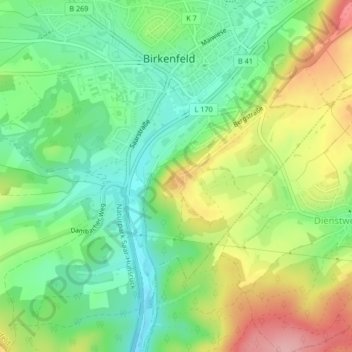
Name: Burg Birkenfeld topographic map, elevation, terrain.
Average elevation: 412 m
Minimum elevation: 356 m
Maximum elevation: 497 m
Make a donation
Gear up for your next adventure:
As an Amazon Associate, this site earns from qualifying purchases at no extra cost to you.