
Make a donation
Gear up for your next adventure:
As an Amazon Associate, this site earns from qualifying purchases at no extra cost to you.
Antipas topographic map
Click on the map to display elevation.
Make a donation
Gear up for your next adventure:
As an Amazon Associate, this site earns from qualifying purchases at no extra cost to you.
Antipas
Temperature ranges from 23 to 32 degrees Celsius, because of its topographic elevation of 320 meters above sea level and proximity to mountainous Bukidnon province, making it one of the cool places in Soccsksargen. The highest temperature is felt during the months of March and April, while the lowest is in December. The long dry season usually lasts from January to April, during which months there is also a marked decrease in water supply for agricultural purposes when some water sources dry up, affecting agricultural productivity. During the peak rainy season, some rivers/creeks overflow, causing low-lying areas to flood.
Make a donation
Gear up for your next adventure:
As an Amazon Associate, this site earns from qualifying purchases at no extra cost to you.
About this map
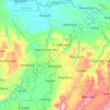
Name: Antipas topographic map, elevation, terrain.
Location: Antipas, North Cotabato, Soccsksargen, 9414, Philippines (7.19564 125.00421 7.32543 125.12363)
Average elevation: 297 m
Minimum elevation: 107 m
Maximum elevation: 691 m
Make a donation
Gear up for your next adventure:
As an Amazon Associate, this site earns from qualifying purchases at no extra cost to you.
Other topographic maps
Click on a map to view its topography, its elevation and its terrain.
Make a donation
Gear up for your next adventure:
As an Amazon Associate, this site earns from qualifying purchases at no extra cost to you.
Kabacan
The landscape is characterized by almost regular landscape of flat terrain. The high mountains and rolling hills leaping close to the river plus the narrow plains have varied topographical features. Other features are moderately sloping and strongly sloping.
Average elevation: 21 m
Make a donation
Gear up for your next adventure:
As an Amazon Associate, this site earns from qualifying purchases at no extra cost to you.
Make a donation
Gear up for your next adventure:
As an Amazon Associate, this site earns from qualifying purchases at no extra cost to you.