Geolocate

Badbury topographic map

Click on the map to display elevation.

About this map

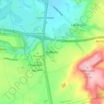
Name: Badbury topographic map, elevation, terrain.

Location: Badbury, Chiseldon, Swindon, England, SN4 0EU, United Kingdom (51.50141 -1.73930 51.54141 -1.69930)

Average elevation: 164 m

Minimum elevation: 105 m

Maximum elevation: 277 m

Other topographic maps

Click on a map to view its topography, its elevation and its terrain.

Highworth

United Kingdom > England > Swindon

Average elevation: 97 m

Shaftsbury Lakes

United Kingdom > England > Swindon

Average elevation: 108 m

Hannington

United Kingdom > England > Swindon

Average elevation: 88 m

Blunsdon

United Kingdom > England > Swindon > Broad Blunsdon

Average elevation: 110 m

Wroughton

United Kingdom > England > Swindon

Average elevation: 153 m

South Marston

United Kingdom > England > Swindon

Average elevation: 101 m

Wanborough

United Kingdom > England > Swindon

Average elevation: 139 m

Chiseldon

United Kingdom > England > Swindon

Average elevation: 171 m

Liddington

United Kingdom > England > Swindon > Liddington

Average elevation: 172 m

Inglesham

United Kingdom > England > Swindon

Average elevation: 77 m

Haydon Wick

United Kingdom > England > Swindon

Average elevation: 104 m

Wroughton

United Kingdom > England > Swindon

Average elevation: 153 m

Wroughton

United Kingdom > England > Swindon

Average elevation: 153 m

Gear up for your next adventure:

🥾Waterproof Hiking Boots - Essential footwear for rugged terrain and wet Canadian trails
🕶️Polarized Sunglasses - Reduces glare from snow and water at high elevations
🎒Backpack Rain Cover - External shield to keep your entire pack dry
🥽Outdoor Goggles - Protective eyewear for outdoor activities
🧢Sun Hat - Wide-brim hat for sun protection

As an Amazon Associate, this site earns from qualifying purchases at no extra cost to you.