Geolocate

Isperih topographic map

Click on the map to display elevation.

About this map

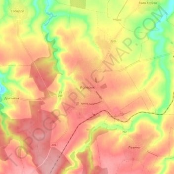
Name: Isperih topographic map, elevation, terrain.

Location: Isperih, Razgrad, Bulgaria (43.67687 26.79014 43.75687 26.87014)

Average elevation: 259 m

Minimum elevation: 184 m

Maximum elevation: 303 m

Gear up for your next adventure:

🔭Compact Binoculars - Lightweight optics for scouting trails and wildlife
🐕Hiking Dog Pack - Let your canine companion carry their own water and food
❄️Traction Ice Cleats - Slip-on spikes for icy trails and winter hiking
🔭Compact Monocular - One-handed bird watching and trail spotting
🧴Insect Repellent - Protect yourself from bugs during outdoor adventures

As an Amazon Associate, this site earns from qualifying purchases at no extra cost to you.