Geolocate

Sundarharaicha topographic map

Click on the map to display elevation.

About this map

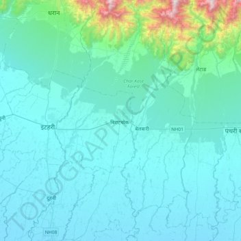
Name: Sundarharaicha topographic map, elevation, terrain.

Location: Sundarharaicha, Morang, Koshi Province, 56611, Nepal (26.50969 87.22304 26.82969 87.54304)

Average elevation: 228 m

Minimum elevation: 76 m

Maximum elevation: 1,621 m

Other topographic maps

Click on a map to view its topography, its elevation and its terrain.

Letang

Nepal > Koshi Province > Morang

Average elevation: 616 m

Ratuwamai-10

Nepal > Koshi Province > Morang

Average elevation: 94 m

Betana Wetlands

Nepal > Koshi Province > Morang

Average elevation: 136 m

Biratnagar

Nepal > Koshi Province > Morang

Average elevation: 70 m

Sundarharaicha

Nepal > Koshi Province > Morang

Average elevation: 126 m

Patahrishanishchare

Nepal > Koshi Province > Morang

Average elevation: 110 m

Gear up for your next adventure:

💧Hydration Bladder - Hands-free hydration solution for long treks
💧Hydration Pack - Hands-free hydration system for long hikes
🧣Evaporative Cooling Towel - Beat the heat during intense summer climbs
🔭Outdoor Binoculars - Lightweight binoculars for birdwatching and hiking
💧Collapsible Water Bottle - Space-saving water bottle for outdoor activities

As an Amazon Associate, this site earns from qualifying purchases at no extra cost to you.