
Make a donation
Gear up for your next adventure:
As an Amazon Associate, this site earns from qualifying purchases at no extra cost to you.
Gap topographic map
Click on the map to display elevation.
Make a donation
Gear up for your next adventure:
As an Amazon Associate, this site earns from qualifying purchases at no extra cost to you.
Gap
Gap is in eastern Lancaster County, in the southern part of Salisbury Township. A small portion of the community extends south into Sadsbury Township. The gap for which the community is named is at an elevation of 580 feet (180 m) above sea level, between Mine Ridge to the west and Gap Hill to the east, both ridges rising to about 750 feet (230 m) above sea level. The community occupies the center of the gap and extends northward downslope into Salisbury Township.
Make a donation
Gear up for your next adventure:
As an Amazon Associate, this site earns from qualifying purchases at no extra cost to you.
About this map
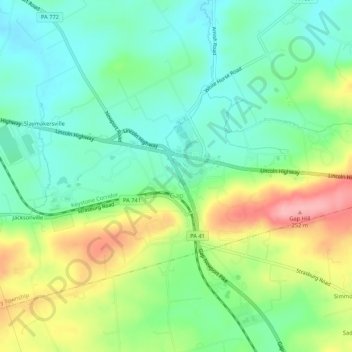
Name: Gap topographic map, elevation, terrain.
Location: Gap, Lancaster County, Pennsylvania, United States (39.97537 -76.04285 40.00367 -75.98965)
Average elevation: 169 m
Minimum elevation: 122 m
Maximum elevation: 257 m
Make a donation
Gear up for your next adventure:
As an Amazon Associate, this site earns from qualifying purchases at no extra cost to you.
Other topographic maps
Click on a map to view its topography, its elevation and its terrain.
Ronks
United States > Pennsylvania > Lancaster County > East Lampeter Township
Average elevation: 115 m
East Earl
United States > Pennsylvania > Lancaster County > East Earl Township
Average elevation: 165 m
Schoeneck
United States > Pennsylvania > Lancaster County > West Cocalico Township
Average elevation: 157 m
Make a donation
Gear up for your next adventure:
As an Amazon Associate, this site earns from qualifying purchases at no extra cost to you.
Conestoga
United States > Pennsylvania > Lancaster County > Conestoga Township
Average elevation: 118 m
Make a donation
Gear up for your next adventure:
As an Amazon Associate, this site earns from qualifying purchases at no extra cost to you.
Eagle Rock
United States > Pennsylvania > Lancaster County > Elizabeth Township
Average elevation: 193 m
Chickies Rock
United States > Pennsylvania > Lancaster County > West Hempfield Township
Average elevation: 106 m
Make a donation
Gear up for your next adventure:
As an Amazon Associate, this site earns from qualifying purchases at no extra cost to you.
Salunga
United States > Pennsylvania > Lancaster County > East Hempfield Township
Average elevation: 118 m
Fertility
United States > Pennsylvania > Lancaster County > East Lampeter Township
Average elevation: 110 m
Glen Moore
United States > Pennsylvania > Lancaster County > Manheim Township
Average elevation: 109 m
Indian Rocks
United States > Pennsylvania > Lancaster County > East Cocalico Township
Average elevation: 161 m
Make a donation
Gear up for your next adventure:
As an Amazon Associate, this site earns from qualifying purchases at no extra cost to you.
Blainsport
United States > Pennsylvania > Lancaster County > West Cocalico Township
Average elevation: 174 m
Make a donation
Gear up for your next adventure:
As an Amazon Associate, this site earns from qualifying purchases at no extra cost to you.
Make a donation
Gear up for your next adventure:
As an Amazon Associate, this site earns from qualifying purchases at no extra cost to you.