Geolocate

Lindby topographic map

Click on the map to display elevation.

About this map

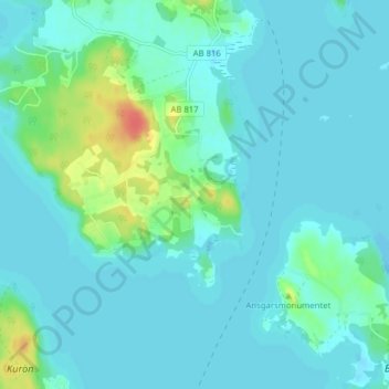
Name: Lindby topographic map, elevation, terrain.

Location: Lindby, Ekerö kommun, Stockholm County, 178 92, Sweden (59.32326 17.50530 59.36326 17.54530)

Average elevation: 8 m

Minimum elevation: -2 m

Maximum elevation: 45 m

Other topographic maps

Click on a map to view its topography, its elevation and its terrain.

Lagnö

Sweden > Stockholm County > Ekerö kommun

Average elevation: 2 m

Ekerö

Sweden > Stockholm County > Ekerö kommun

Average elevation: 15 m

Ekerö

Sweden > Stockholm County > Ekerö kommun

Average elevation: 15 m

Gear up for your next adventure:

🛏️Sleeping Bag - Warm and compact sleeping bags for outdoor camping
🧢Hiking Sun Hat - Wide-brimmed protection for exposed mountain ridges
🥾Trekking Boots - Durable boots for long-distance trekking
🦶Hiking Shoe Insoles - Added support for high arches and long days on feet
🚑Survival Whistle - Signal for help across long distances in mountains

As an Amazon Associate, this site earns from qualifying purchases at no extra cost to you.