
Grassi Lakes topographic map
Click on the map to display elevation.
About this map
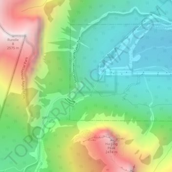
Name: Grassi Lakes topographic map, elevation, terrain.
Location: Grassi Lakes, Town of Canmore, Alberta, Canada (51.07249 -115.40613 51.07300 -115.40544)
Average elevation: 1,803 m
Minimum elevation: 1,374 m
Maximum elevation: 2,566 m
Town of Canmore trails, hiking, mountain biking, running and outdoor activities
Other topographic maps
Click on a map to view its topography, its elevation and its terrain.
Canmore
Canada > Alberta > Town of Canmore
Elevation Place opened in April 2013 as Canmore's new recreation facility. Construction of the facility began in 2012 to replace the Canmore Recreation Centre (the community's old facility). The facility offers an 8-lane 25m lap pool, a world class climbing wall developed by Walltopia, two cardio rooms, a…
Average elevation: 1,565 m
Bow Valley Wildland Provincial Park
Canada > Alberta > Town of Canmore > Canmore
Average elevation: 1,844 m
Canmore
Canada > Alberta > Town of Canmore
Elevation Place opened in April 2013 as Canmore's new recreation facility. Construction of the facility began in 2012 to go alongside the Canmore Recreation Centre (the community's old facility). The facility offers an 8-lane 25m lap pool, a world class climbing wall developed by Walltopia, two cardio rooms, a…
Average elevation: 1,565 m