Geolocate

Memphis topographic map

Click on the map to display elevation.

About this map

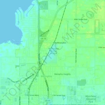
Name: Memphis topographic map, elevation, terrain.

Location: Memphis, Manatee County, Florida, United States (27.52470 -82.57495 27.56529 -82.53571)

Average elevation: 6 m

Minimum elevation: -1 m

Maximum elevation: 13 m

Gear up for your next adventure:

🔭Outdoor Binoculars - Lightweight binoculars for birdwatching and hiking
🧢Sun Protection Cap - Breathable cap to protect from sun exposure
🧦Thermal Socks - Warm socks for winter hiking or camping
👟Leg Gaiters - Keep debris, mud, and snow out of your boots
👟Trail Running Shoes - Agile footwear for fast-paced topographic exploration

As an Amazon Associate, this site earns from qualifying purchases at no extra cost to you.