Geolocate

Vilalba topographic map

Click on the map to display elevation.

About this map

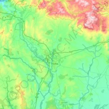
Name: Vilalba topographic map, elevation, terrain.

Location: Vilalba, Terra Chá, Lugo, Galicia, Spain (43.18767 -7.83176 43.44779 -7.51555)

Average elevation: 509 m

Minimum elevation: 341 m

Maximum elevation: 961 m

Other topographic maps

Click on a map to view its topography, its elevation and its terrain.

Broz

Spain > Galicia > Terra Chá > Vilalba

Average elevation: 466 m

Bonaire

Spain > Galicia > Terra Chá > Guitiriz

Average elevation: 507 m

A Fontemiñá

Spain > Galicia > Terra Chá > A Pastoriza > A Igrexa

Average elevation: 490 m

Goela

Spain > Galicia > Terra Chá > Abadín

Average elevation: 599 m

Gear up for your next adventure:

🧦Merino Wool Socks - Moisture-wicking comfort for long-distance hiking
🐕Hiking Dog Pack - Let your canine companion carry their own water and food
🥾Lightweight Hiking Boots - Boots for comfort and mobility on long hikes
🧥Softshell Jacket - Windproof and breathable jacket for hiking
🧥Thermal Fleece Jacket - Versatile insulation for changing mountain temperatures

As an Amazon Associate, this site earns from qualifying purchases at no extra cost to you.