Geolocate

Hatton topographic map

Click on the map to display elevation.

About this map

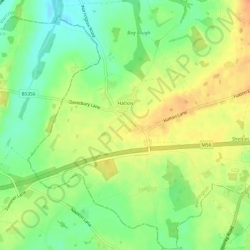
Name: Hatton topographic map, elevation, terrain.

Location: Hatton, Warrington, England, United Kingdom (53.32231 -2.61981 53.34912 -2.57927)

Average elevation: 69 m

Minimum elevation: 48 m

Maximum elevation: 90 m

Other topographic maps

Click on a map to view its topography, its elevation and its terrain.

Lymm

United Kingdom > England > Warrington

Average elevation: 31 m

Warrington

United Kingdom > England > Warrington

Average elevation: 20 m

Appleton Thorn

United Kingdom > England > Warrington

Average elevation: 61 m

Arbury

United Kingdom > England > Warrington > Winwick

Average elevation: 22 m

Sankey Brook

United Kingdom > England > Warrington > Warrington

Average elevation: 12 m

Cuerdley Cross

United Kingdom > England > Warrington

Average elevation: 19 m

Diggle Green

United Kingdom > England > Warrington > Kenyon

Average elevation: 29 m

Hollins Green

United Kingdom > England > Warrington

Average elevation: 18 m

Burtonwood

United Kingdom > England > Warrington

Average elevation: 26 m

Lately Common

United Kingdom > England > Warrington > Glazebury

Average elevation: 21 m

Gear up for your next adventure:

🗺️Topographic Maps - Detailed maps to explore trails, mountains, and wilderness areas
🧥Softshell Jacket - Windproof and breathable jacket for hiking
🥾Trekking Boots - Durable boots for long-distance trekking
🧭Orienteering Kit - Tools for map reading and navigation in the wild
🧢Beanie Hat - Keep your head warm in cold weather

As an Amazon Associate, this site earns from qualifying purchases at no extra cost to you.