Geolocate

Pioneer topographic map

Click on the map to display elevation.

About this map

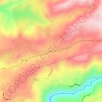
Name: Pioneer topographic map, elevation, terrain.

Location: Pioneer, Amador County, California, United States (38.41186 -120.59187 38.45186 -120.55187)

Average elevation: 888 m

Minimum elevation: 584 m

Maximum elevation: 1,072 m

Other topographic maps

Click on a map to view its topography, its elevation and its terrain.

Lake Tabeaud

United States > California > Amador County

Average elevation: 570 m

Plymouth

United States > California > Amador County

Average elevation: 337 m

Gear up for your next adventure:

🌡️Emergency Mylar Blankets - Compact thermal protection for unexpected nights outdoors
🦟Insect Repellent - Keep mosquitoes and black flies away in wooded areas
Camping Essentials - All-in-one gear for a comfortable camping trip
🥾Trekking Boots - Durable boots for long-distance trekking
🪑Insulated Seat Pad - Protect your seat from cold rocks and wet logs

As an Amazon Associate, this site earns from qualifying purchases at no extra cost to you.