Geolocate

Plymouth topographic map

Click on the map to display elevation.

About this map

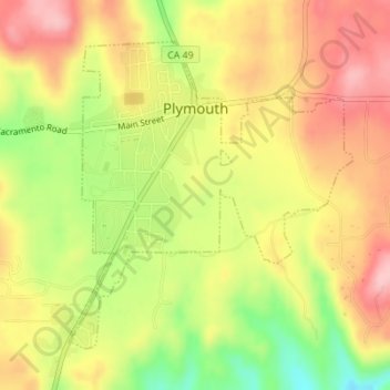
Name: Plymouth topographic map, elevation, terrain.

Location: Plymouth, Amador County, California, United States (38.46518 -120.85590 38.48646 -120.83073)

Average elevation: 337 m

Minimum elevation: 247 m

Maximum elevation: 404 m

Other topographic maps

Click on a map to view its topography, its elevation and its terrain.

Pioneer

United States > California > Amador County

Average elevation: 888 m

Lake Tabeaud

United States > California > Amador County

Average elevation: 570 m

Gear up for your next adventure:

Camping Coffee Maker - Brew fresh coffee anywhere on the topographic map
🎒Hiking Backpack - Lightweight and ergonomic backpacks for day hikes or multi-day treks
🧴Sunscreen SPF - Broad-spectrum sunscreen for outdoor activities
🪑Insulated Seat Pad - Protect your seat from cold rocks and wet logs
🧣Evaporative Cooling Towel - Beat the heat during intense summer climbs

As an Amazon Associate, this site earns from qualifying purchases at no extra cost to you.