Geolocate

Tathawade topographic map

Click on the map to display elevation.

About this map

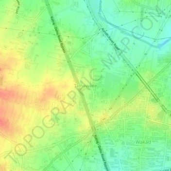
Name: Tathawade topographic map, elevation, terrain.

Location: Tathawade, Mulshi, Pune District, Maharashtra, 410005, India (18.59540 73.73019 18.63540 73.77019)

Average elevation: 577 m

Minimum elevation: 554 m

Maximum elevation: 602 m

Other topographic maps

Click on a map to view its topography, its elevation and its terrain.

Aamby Valley

India > Maharashtra > Mulshi

Average elevation: 710 m

Manas Lake

India > Maharashtra > Mulshi > Bhukum

Average elevation: 703 m

Mulshi Lake

India > Maharashtra > Mulshi > Chachivali

Average elevation: 710 m

Katarkhadak

India > Maharashtra > Mulshi

Average elevation: 810 m

Mula

India > Maharashtra > Mulshi

Average elevation: 658 m

Kasarsai

India > Maharashtra > Mulshi > Nere

Average elevation: 605 m

Gear up for your next adventure:

💡Portable Camping Lamp - Rechargeable lamp for campsite lighting
🧥Packable Rain Jacket - Breathable waterproof layer for unpredictable weather
🦶Anti-Blister Balm - Prevents friction and hotspots during long ascents
🥾Hiking Shoes - Durable and comfortable shoes for trail hiking
🔦LED Headlamp - Hands-free lighting for early morning starts or late finishes

As an Amazon Associate, this site earns from qualifying purchases at no extra cost to you.