Geolocate

Gouda topographic map

Click on the map to display elevation.

About this map

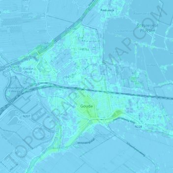
Name: Gouda topographic map, elevation, terrain.

Location: Gouda, South Holland, Netherlands (51.99626 4.65945 52.04012 4.75733)

Average elevation: -1 m

Minimum elevation: -8 m

Maximum elevation: 6 m

Other topographic maps

Click on a map to view its topography, its elevation and its terrain.

Meije

Netherlands > South Holland > Nieuwkoop

Average elevation: -2 m

Langeraar

Netherlands > South Holland

Average elevation: -3 m

Broekhuizen

Netherlands > South Holland > Gouda

Average elevation: -1 m

Ankerpark

Netherlands > South Holland > Leiden

Average elevation: 3 m

Botlek

Netherlands > South Holland

Average elevation: 3 m

Middelsluis

Netherlands > South Holland > Numansdorp

Average elevation: 0 m

Weerestein

Netherlands > South Holland > Hillegom

Average elevation: 0 m

Weerestein

Netherlands > South Holland > Hillegom

Average elevation: 0 m

Meijendel

Netherlands > South Holland > Wassenaar

Average elevation: 6 m

Coepelduynen

Netherlands > South Holland > Katwijk

Average elevation: 4 m

Het Park

Netherlands > South Holland > Rotterdam

Average elevation: 4 m

Waalhaven

Netherlands > South Holland > Rotterdam

Average elevation: 3 m

Gear up for your next adventure:

🔥Camping Stove - Portable stoves to cook outdoors with ease
👖Convertible Hiking Pants - Zip-off legs to adapt to changing weather conditions
🚲Heavy Duty Bike Lock - Secure your bike at the trailhead or during stops
🥾Trail Hiking Shoes - Durable shoes designed for rugged trails
🥾Lightweight Hiking Shoes - Comfortable shoes for day hikes

As an Amazon Associate, this site earns from qualifying purchases at no extra cost to you.