Geolocate

Hagby topographic map

Click on the map to display elevation.

About this map

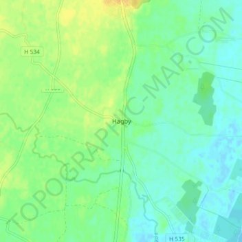
Name: Hagby topographic map, elevation, terrain.

Location: Hagby, Kalmar kommun, Kalmar County, 388 96, Sweden (56.53422 16.16052 56.57422 16.20052)

Average elevation: 10 m

Minimum elevation: -1 m

Maximum elevation: 26 m

Other topographic maps

Click on a map to view its topography, its elevation and its terrain.

Nybro kommun

Sweden > Kalmar County

Average elevation: 109 m

Emmaboda kommun

Sweden > Kalmar County

Average elevation: 141 m

Hultsfreds kommun

Sweden > Kalmar County

Average elevation: 143 m

Emmaboda kommun

Sweden > Kalmar County

Average elevation: 141 m

Hansa City

Sweden > Kalmar County

Average elevation: 7 m

Högsby kommun

Sweden > Kalmar County

Average elevation: 97 m

Store Hindsjön

Sweden > Kalmar County

Average elevation: 118 m

Mönsterås kommun

Sweden > Kalmar County

Average elevation: 26 m

Alen

Sweden > Kalmar County

Average elevation: 142 m

Oskarshamns kommun

Sweden > Kalmar County

Average elevation: 63 m

Kalmar kommun

Sweden > Kalmar County

Average elevation: 28 m

Gear up for your next adventure:

🧰Emergency Multi-Tool - Compact multi-tool for outdoor survival
🧢Sun Protection Cap - Breathable cap to protect from sun exposure
🚲Bike Repair Kit - Essential tools for on-trail mechanical issues
🚲MTB Frame Bag - Carry tools and maps directly on your bicycle frame
🎒Hiking Daypack - Lightweight and durable backpacks for day trips and excursions

As an Amazon Associate, this site earns from qualifying purchases at no extra cost to you.