
Uinta River topographic map
Interactive map
Click on the map to display elevation.
About this map
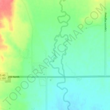
Name: Uinta River topographic map, elevation, terrain.
Location: Uinta River, Uintah County, Utah, 84026, United States (40.30204 -109.85822 40.31240 -109.85349)
Average elevation: 1,545 m
Minimum elevation: 1,523 m
Maximum elevation: 1,588 m
Other topographic maps
Click on a map to view its topography, its elevation and its terrain.
Naples
United States > Utah > Uintah County
Naples, Uintah County, Utah, United States
Average elevation: 1,595 m
Randlett
United States > Utah > Uintah County
Randlett, Uintah County, Utah, 84063, United States
Average elevation: 1,485 m
Ballard
United States > Utah > Uintah County
Ballard, Uintah County, Utah, United States
Average elevation: 1,551 m
Lily Lake
United States > Utah > Uintah County
Lily Lake, Uintah County, Utah, United States
Average elevation: 3,194 m
Vernal
United States > Utah > Uintah County
Vernal, Uintah County, Utah, United States
Average elevation: 1,625 m
Jensen
United States > Utah > Uintah County > Jensen
Jensen, Uintah County, Utah, 84035, United States
Average elevation: 1,470 m