
Make a donation
Gear up for your next adventure:
As an Amazon Associate, this site earns from qualifying purchases at no extra cost to you.
Zenica-Doboj Canton topographic map
Click on the map to display elevation.
Make a donation
Gear up for your next adventure:
As an Amazon Associate, this site earns from qualifying purchases at no extra cost to you.
Zenica-Doboj Canton
The canton is situated in the inner Dinarides, and consists of three distinct topographical areas. The high mountainous southern region with an altitude of 501–1,473 m (1,644–4,833 ft), the highlands of the central region with altitudes between 201–500 m (659–1,640 ft), and the northern lowlands. River Bosna is the major river that flows through the region, and the lowlands in the north form part of the river valley. The river causes floods during seasons of high precipitation. The canton gets rainfall throughout the year, with the lowlands getting an average of 70 cm (28 in) and the highlands receiving 100 cm (39 in) of rain. The region has a temperate climate.
Make a donation
Gear up for your next adventure:
As an Amazon Associate, this site earns from qualifying purchases at no extra cost to you.
About this map
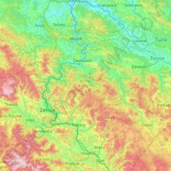
Name: Zenica-Doboj Canton topographic map, elevation, terrain.
Average elevation: 667 m
Minimum elevation: 143 m
Maximum elevation: 2,089 m
Make a donation
Gear up for your next adventure:
As an Amazon Associate, this site earns from qualifying purchases at no extra cost to you.
Other topographic maps
Click on a map to view its topography, its elevation and its terrain.
Mosor
Bosnia and Herzegovina > Federation of Bosnia and Herzegovina > City of Široki Brijeg > Gostuša
Average elevation: 633 m
Gračanica
Bosnia and Herzegovina > Federation of Bosnia and Herzegovina > Town of Gračanica
Average elevation: 267 m
Make a donation
Gear up for your next adventure:
As an Amazon Associate, this site earns from qualifying purchases at no extra cost to you.
Džanani
Bosnia and Herzegovina > Federation of Bosnia and Herzegovina > City of Cazin > Šturlić
Average elevation: 345 m
Visoko
Bosnia and Herzegovina > Federation of Bosnia and Herzegovina > Grad Visoko
The Visoko municipality covers 232 square kilometres with several characteristic, morphologically distinctive valleys formed by the foothills of the Central Bosnian mountains including Ozren, Vranica and Zvijezda. The altitude of the region ranges from 400 to 1,050 metres. Visoko's natural environment is…
Average elevation: 527 m
Make a donation
Gear up for your next adventure:
As an Amazon Associate, this site earns from qualifying purchases at no extra cost to you.
Kupres
Bosnia and Herzegovina > Federation of Bosnia and Herzegovina
Kupres is located at an altitude between 1,120 and 1,250 m (3,675 and 4,101 ft) and averages 55 days a year of snowfall due to its advantageous location in the Dinaric Alps.
Average elevation: 1,254 m
Tuzla
Bosnia and Herzegovina > Federation of Bosnia and Herzegovina > City of Tuzla
Average elevation: 349 m
Bugojno
Bosnia and Herzegovina > Federation of Bosnia and Herzegovina
The municipality has an average elevation of 570 metres above sea level. Much of its 366 km2 is forested. The terrain is mountainous with several prominent features. Stožer (1662m), Kalin (1,530m) and Rudina (1,385m) are the tallest mountains in Bugojno.
Average elevation: 647 m
Make a donation
Gear up for your next adventure:
As an Amazon Associate, this site earns from qualifying purchases at no extra cost to you.
Zenica
Bosnia and Herzegovina > Federation of Bosnia and Herzegovina > City of Zenica
The city is geographically located in the heart of Bosnia. The settled area is 43.01 km2 (16.61 sq mi) and of the city proper covers 558.5 km2 (215.6 sq mi). Elevation is 310–350 m (1,017–1,148 ft). The rivers Bosna, Lašva, Babina, and Kočeva flow through the settlement. A moderate continental climate…
Average elevation: 730 m
Kraljeva Sutjeska
Bosnia and Herzegovina > Federation of Bosnia and Herzegovina
Average elevation: 695 m
Cazin
Bosnia and Herzegovina > Federation of Bosnia and Herzegovina > City of Cazin
Average elevation: 375 m
Make a donation
Gear up for your next adventure:
As an Amazon Associate, this site earns from qualifying purchases at no extra cost to you.
Posušje
Bosnia and Herzegovina > Federation of Bosnia and Herzegovina
It lies in the Posuško polje, at an altitude of 675 m, at the intersection of the road from Split and Imotski in Croatia towards Tomislavgrad and Mostar.
Average elevation: 752 m
Konjic
Bosnia and Herzegovina > Federation of Bosnia and Herzegovina > Town of Konjic
Average elevation: 550 m
Visoko
Bosnia and Herzegovina > Federation of Bosnia and Herzegovina > Grad Visoko
The Visoko municipality covers 232 square kilometres with several characteristic, morphologically distinctive valleys formed by the foothills of the Central Bosnian mountains including Ozren, Vranica and Zvijezda. The altitude of the region ranges from 400 to 1,050 metres. Visoko's natural environment is…
Average elevation: 527 m
Make a donation
Gear up for your next adventure:
As an Amazon Associate, this site earns from qualifying purchases at no extra cost to you.
Greb
Bosnia and Herzegovina > Federation of Bosnia and Herzegovina > Markovići
Average elevation: 981 m
Banjani
Bosnia and Herzegovina > Federation of Bosnia and Herzegovina > Town of Bosanska Krupa
Average elevation: 308 m
Tuzla
Bosnia and Herzegovina > Federation of Bosnia and Herzegovina > City of Tuzla
Average elevation: 349 m
Make a donation
Gear up for your next adventure:
As an Amazon Associate, this site earns from qualifying purchases at no extra cost to you.
Vrbljani
Bosnia and Herzegovina > Federation of Bosnia and Herzegovina > Town of Konjic
Average elevation: 727 m
Gudelji
Bosnia and Herzegovina > Federation of Bosnia and Herzegovina > Jazvine
Average elevation: 472 m
Make a donation
Gear up for your next adventure:
As an Amazon Associate, this site earns from qualifying purchases at no extra cost to you.
Brđani
Bosnia and Herzegovina > Federation of Bosnia and Herzegovina > City of Tuzla
Average elevation: 370 m
Gornja Bukovica
Bosnia and Herzegovina > Federation of Bosnia and Herzegovina
Average elevation: 492 m
Lukavac
Bosnia and Herzegovina > Federation of Bosnia and Herzegovina > Town of Lukavac
Average elevation: 222 m
Plane
Bosnia and Herzegovina > Federation of Bosnia and Herzegovina > City of Tuzla
Average elevation: 240 m
Make a donation
Gear up for your next adventure:
As an Amazon Associate, this site earns from qualifying purchases at no extra cost to you.
Međugorje
Bosnia and Herzegovina > Federation of Bosnia and Herzegovina
The name Medjugorje literally means "between mountains". At an altitude of 200 m (660 ft) above sea level it has a mild Mediterranean climate. The town consists of an ethnically homogeneous Croat population of 2,306. The Catholic parish includes four neighbouring villages: Bijakovići, Vionica, Miletina and…
Average elevation: 203 m
Podorašac
Bosnia and Herzegovina > Federation of Bosnia and Herzegovina > Town of Konjic
Average elevation: 641 m
Make a donation
Gear up for your next adventure:
As an Amazon Associate, this site earns from qualifying purchases at no extra cost to you.
Vareš
Bosnia and Herzegovina > Federation of Bosnia and Herzegovina
The Vareš region also has possibilities for winter tourism development. Due to its position and elevation snow stays longer than in other regions, and the beautiful areas surrounding it are really good for skiing and skating. The mountain resort Doli is located on Zvijezda Mountain.
Average elevation: 1,091 m
Brgule
Bosnia and Herzegovina > Federation of Bosnia and Herzegovina > City of Tuzla
Average elevation: 265 m
Livno
Bosnia and Herzegovina > Federation of Bosnia and Herzegovina > City of Livno
Average elevation: 907 m
Make a donation
Gear up for your next adventure:
As an Amazon Associate, this site earns from qualifying purchases at no extra cost to you.
Dinaric Alps
Bosnia and Herzegovina > Federation of Bosnia and Herzegovina > City of Livno
Average elevation: 1,599 m
Make a donation
Gear up for your next adventure:
As an Amazon Associate, this site earns from qualifying purchases at no extra cost to you.
Tuzla
Bosnia and Herzegovina > Federation of Bosnia and Herzegovina > City of Tuzla
Average elevation: 349 m
Čapljina
Bosnia and Herzegovina > Federation of Bosnia and Herzegovina > City of Čapljina
Average elevation: 98 m
Una
Bosnia and Herzegovina > Federation of Bosnia and Herzegovina > City of Bihać > Bihać
Average elevation: 255 m
Una
Bosnia and Herzegovina > Federation of Bosnia and Herzegovina > City of Bihać > Bihać
Average elevation: 255 m
Make a donation
Gear up for your next adventure:
As an Amazon Associate, this site earns from qualifying purchases at no extra cost to you.
Make a donation
Gear up for your next adventure:
As an Amazon Associate, this site earns from qualifying purchases at no extra cost to you.
Brgule
Bosnia and Herzegovina > Federation of Bosnia and Herzegovina > City of Tuzla
Average elevation: 265 m
Brgule
Bosnia and Herzegovina > Federation of Bosnia and Herzegovina > City of Tuzla
Average elevation: 265 m
Make a donation
Gear up for your next adventure:
As an Amazon Associate, this site earns from qualifying purchases at no extra cost to you.
Tukovi
Bosnia and Herzegovina > Federation of Bosnia and Herzegovina > City of Bihać
Average elevation: 831 m
Make a donation
Gear up for your next adventure:
As an Amazon Associate, this site earns from qualifying purchases at no extra cost to you.
Visoko
Bosnia and Herzegovina > Federation of Bosnia and Herzegovina > Grad Visoko
The Visoko municipality covers 232 square kilometres with several characteristic, morphologically distinctive valleys formed by the foothills of the Central Bosnian mountains including Ozren, Vranica and Zvijezda. The altitude of the region ranges from 400 to 1,050 metres. Visoko's natural environment is…
Average elevation: 527 m
Mrkovići
Bosnia and Herzegovina > Federation of Bosnia and Herzegovina > City of Sarajevo
Average elevation: 938 m
Make a donation
Gear up for your next adventure:
As an Amazon Associate, this site earns from qualifying purchases at no extra cost to you.
Dinaric Alps
Bosnia and Herzegovina > Federation of Bosnia and Herzegovina > City of Livno
Average elevation: 1,599 m
Make a donation
Gear up for your next adventure:
As an Amazon Associate, this site earns from qualifying purchases at no extra cost to you.
Dubovo brdo
Bosnia and Herzegovina > Federation of Bosnia and Herzegovina > City of Čapljina > Trebižat
Average elevation: 149 m
Make a donation
Gear up for your next adventure:
As an Amazon Associate, this site earns from qualifying purchases at no extra cost to you.
Donje Vukovsko
Bosnia and Herzegovina > Federation of Bosnia and Herzegovina
Average elevation: 1,241 m
Mošćanica
Bosnia and Herzegovina > Federation of Bosnia and Herzegovina > City of Zenica
Average elevation: 645 m
Drvar
Bosnia and Herzegovina > Federation of Bosnia and Herzegovina
This extremely hilly region, comprising the town of Drvar and the numerous outlying villages, covers approximately 1,030 square kilometres (400 square miles). The town is mainly situated on the left side of the River Unac, and its elevation is approximately 480 meters (1,574 feet).
Average elevation: 692 m
Make a donation
Gear up for your next adventure:
As an Amazon Associate, this site earns from qualifying purchases at no extra cost to you.
Prenj
Bosnia and Herzegovina > Federation of Bosnia and Herzegovina > Town of Stolac
Average elevation: 169 m
Make a donation
Gear up for your next adventure:
As an Amazon Associate, this site earns from qualifying purchases at no extra cost to you.
Vranica
Bosnia and Herzegovina > Federation of Bosnia and Herzegovina > City of Zenica
Average elevation: 850 m
Livno
Bosnia and Herzegovina > Federation of Bosnia and Herzegovina > City of Livno
Average elevation: 907 m
Make a donation
Gear up for your next adventure:
As an Amazon Associate, this site earns from qualifying purchases at no extra cost to you.
Livno
Bosnia and Herzegovina > Federation of Bosnia and Herzegovina > City of Livno
Average elevation: 907 m
Nahorevo
Bosnia and Herzegovina > Federation of Bosnia and Herzegovina > City of Sarajevo
Average elevation: 864 m
Drvar
Bosnia and Herzegovina > Federation of Bosnia and Herzegovina
This extremely hilly region comprising the town of Drvar and the numerous outlying villages covers approximately 1,030 square kilometers (400 square miles). The town itself is mainly spread out from the left side of the river Unac, and its elevation is approximately 480 meters (1,574 feet).
Average elevation: 692 m
Make a donation
Gear up for your next adventure:
As an Amazon Associate, this site earns from qualifying purchases at no extra cost to you.
Trubar
Bosnia and Herzegovina > Federation of Bosnia and Herzegovina > City of Bihać
Average elevation: 692 m
Ljubuški
Bosnia and Herzegovina > Federation of Bosnia and Herzegovina > Grad Ljubuški
Average elevation: 133 m
Prenj
Bosnia and Herzegovina > Federation of Bosnia and Herzegovina > Town of Stolac
Average elevation: 169 m
Make a donation
Gear up for your next adventure:
As an Amazon Associate, this site earns from qualifying purchases at no extra cost to you.
Ripač
Bosnia and Herzegovina > Federation of Bosnia and Herzegovina > City of Bihać
Average elevation: 316 m
Mlakva
Bosnia and Herzegovina > Federation of Bosnia and Herzegovina > Kute
Average elevation: 1,260 m
Make a donation
Gear up for your next adventure:
As an Amazon Associate, this site earns from qualifying purchases at no extra cost to you.
Nahorevo
Bosnia and Herzegovina > Federation of Bosnia and Herzegovina > City of Sarajevo
Average elevation: 864 m
Svinjašnica
Bosnia and Herzegovina > Federation of Bosnia and Herzegovina > Town of Zavidovići
Average elevation: 446 m
Ljubuški
Bosnia and Herzegovina > Federation of Bosnia and Herzegovina > Grad Ljubuški
Average elevation: 133 m
Make a donation
Gear up for your next adventure:
As an Amazon Associate, this site earns from qualifying purchases at no extra cost to you.