
Make a donation
Gear up for your next adventure:
As an Amazon Associate, this site earns from qualifying purchases at no extra cost to you.
Čvrsnica topographic map
Click on the map to display elevation.
Make a donation
Gear up for your next adventure:
As an Amazon Associate, this site earns from qualifying purchases at no extra cost to you.
About this map
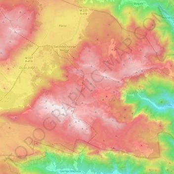
Name: Čvrsnica topographic map, elevation, terrain.
Average elevation: 1,365 m
Minimum elevation: 200 m
Maximum elevation: 2,213 m
Make a donation
Gear up for your next adventure:
As an Amazon Associate, this site earns from qualifying purchases at no extra cost to you.
Other topographic maps
Click on a map to view its topography, its elevation and its terrain.
City of Sarajevo
Bosnia and Herzegovina > Federation of Bosnia and Herzegovina
Average elevation: 810 m
Posušje
Bosnia and Herzegovina > Federation of Bosnia and Herzegovina
It lies in the Posuško polje, at an altitude of 675 m, at the intersection of the road from Split and Imotski in Croatia towards Tomislavgrad and Mostar.
Average elevation: 752 m
Make a donation
Gear up for your next adventure:
As an Amazon Associate, this site earns from qualifying purchases at no extra cost to you.
Grude municipality
Bosnia and Herzegovina > Federation of Bosnia and Herzegovina
Average elevation: 466 m
Gračanica
Bosnia and Herzegovina > Federation of Bosnia and Herzegovina > Town of Gračanica
Average elevation: 267 m
Vrbljani
Bosnia and Herzegovina > Federation of Bosnia and Herzegovina > Town of Konjic
Average elevation: 727 m
Make a donation
Gear up for your next adventure:
As an Amazon Associate, this site earns from qualifying purchases at no extra cost to you.
Gudelji
Bosnia and Herzegovina > Federation of Bosnia and Herzegovina > Jazvine
Average elevation: 472 m
Brđani
Bosnia and Herzegovina > Federation of Bosnia and Herzegovina > City of Tuzla
Average elevation: 370 m
Make a donation
Gear up for your next adventure:
As an Amazon Associate, this site earns from qualifying purchases at no extra cost to you.
Gornja Bukovica
Bosnia and Herzegovina > Federation of Bosnia and Herzegovina
Average elevation: 492 m
Lukavac
Bosnia and Herzegovina > Federation of Bosnia and Herzegovina > Town of Lukavac
Average elevation: 222 m
Plane
Bosnia and Herzegovina > Federation of Bosnia and Herzegovina > City of Tuzla
Average elevation: 240 m
Zenica-Doboj Canton
Bosnia and Herzegovina > Federation of Bosnia and Herzegovina
The canton is situated in the inner Dinarides, and consists of three distinct topographical areas. The high mountainous southern region with an altitude of 501–1,473 m (1,644–4,833 ft), the highlands of the central region with altitudes between 201–500 m (659–1,640 ft), and the northern lowlands. River…
Average elevation: 667 m
Make a donation
Gear up for your next adventure:
As an Amazon Associate, this site earns from qualifying purchases at no extra cost to you.
Central Bosnia Canton
Bosnia and Herzegovina > Federation of Bosnia and Herzegovina
Average elevation: 942 m
Neretva
Bosnia and Herzegovina > Federation of Bosnia and Herzegovina
Its source and headwaters gorge are situated deep in the Dinaric Alps at the base of the Zelengora and Lebršnik mountains, specifically under the Gredelj saddle. The river source is at 1,227 meters above sea level and consists of five small and distinct wellsprings. On its 90 kilometers course through the…
Average elevation: 786 m
West Herzegovina Canton
Bosnia and Herzegovina > Federation of Bosnia and Herzegovina
This region, before the war, was one of the poorest regions in BiH. Today it is one of the richest. Despite the canton's small geographical area size, its agricultural sector is important. In the canton, 30,000 ha (120 sq miles) is used for agriculture; 84,000 ha (320 sq miles) is forest. Around 6,000 ha of…
Average elevation: 593 m
Visoko
Bosnia and Herzegovina > Federation of Bosnia and Herzegovina > Grad Visoko
The Visoko municipality covers 232 square kilometres with several characteristic, morphologically distinctive valleys formed by the foothills of the Central Bosnian mountains including Ozren, Vranica and Zvijezda. The altitude of the region ranges from 400 to 1,050 metres. Visoko's natural environment is…
Average elevation: 527 m
Make a donation
Gear up for your next adventure:
As an Amazon Associate, this site earns from qualifying purchases at no extra cost to you.
Bjelašnica
Bosnia and Herzegovina > Federation of Bosnia and Herzegovina > City of Istočno Sarajevo
Bjelašnica (Serbian Cyrillic: Бјелашница, pronounced [bjělaːʃnit͡sa]) is a mountain in the Dinaric Alps in central Bosnia and Herzegovina. It is to the southwest of Sarajevo, bordering Mount Igman. Bjelašnica's tallest peak, by which the mountain group got its name, rises to an elevation of…
Average elevation: 1,097 m
Podorašac
Bosnia and Herzegovina > Federation of Bosnia and Herzegovina > Town of Konjic
Average elevation: 641 m
Make a donation
Gear up for your next adventure:
As an Amazon Associate, this site earns from qualifying purchases at no extra cost to you.
Greb
Bosnia and Herzegovina > Federation of Bosnia and Herzegovina > Markovići
Average elevation: 981 m
Rujnica
Bosnia and Herzegovina > Federation of Bosnia and Herzegovina > City of Cazin > Rujnica
Average elevation: 303 m
Vareš
Bosnia and Herzegovina > Federation of Bosnia and Herzegovina
The Vareš region also has possibilities for winter tourism development. Due to its position and elevation snow stays longer than in other regions, and the beautiful areas surrounding it are really good for skiing and skating. The mountain resort Doli is located on Zvijezda Mountain.
Average elevation: 1,091 m
Brgule
Bosnia and Herzegovina > Federation of Bosnia and Herzegovina > City of Tuzla
Average elevation: 265 m
Make a donation
Gear up for your next adventure:
As an Amazon Associate, this site earns from qualifying purchases at no extra cost to you.
Banjani
Bosnia and Herzegovina > Federation of Bosnia and Herzegovina > Town of Bosanska Krupa
Average elevation: 308 m
Bihać
Bosnia and Herzegovina > Federation of Bosnia and Herzegovina > City of Bihać
Average elevation: 368 m
Svrake
Bosnia and Herzegovina > Federation of Bosnia and Herzegovina > Svrake
Average elevation: 639 m
Make a donation
Gear up for your next adventure:
As an Amazon Associate, this site earns from qualifying purchases at no extra cost to you.
Pivnice
Bosnia and Herzegovina > Federation of Bosnia and Herzegovina > City of Cazin > Pivnice
Average elevation: 379 m
Livno
Bosnia and Herzegovina > Federation of Bosnia and Herzegovina > City of Livno
Average elevation: 907 m
Make a donation
Gear up for your next adventure:
As an Amazon Associate, this site earns from qualifying purchases at no extra cost to you.
Dinaric Alps
Bosnia and Herzegovina > Federation of Bosnia and Herzegovina > City of Livno
Average elevation: 1,599 m
Mostar
Bosnia and Herzegovina > Federation of Bosnia and Herzegovina > City of Mostar
Average elevation: 221 m
Make a donation
Gear up for your next adventure:
As an Amazon Associate, this site earns from qualifying purchases at no extra cost to you.
Zenica
Bosnia and Herzegovina > Federation of Bosnia and Herzegovina > City of Zenica
The city is geographically located in the heart of Bosnia. The settled area is 43.01 km2 (16.61 mi2) and of the city proper covers 558.5 km2 (215.6 mi2). Elevation is 310–350 m (1,017–1,148 ft). The rivers Bosna, Lašva, Babina, and Kočeva flow through the settlement. A moderate continental climate…
Average elevation: 555 m
Tuzla
Bosnia and Herzegovina > Federation of Bosnia and Herzegovina > City of Tuzla
Average elevation: 349 m
Make a donation
Gear up for your next adventure:
As an Amazon Associate, this site earns from qualifying purchases at no extra cost to you.
Čapljina
Bosnia and Herzegovina > Federation of Bosnia and Herzegovina > City of Čapljina
Average elevation: 98 m
Posavina Canton
Bosnia and Herzegovina > Federation of Bosnia and Herzegovina
Average elevation: 131 m
Herzeg-Bosnia County
Bosnia and Herzegovina > Federation of Bosnia and Herzegovina
Average elevation: 930 m
Make a donation
Gear up for your next adventure:
As an Amazon Associate, this site earns from qualifying purchases at no extra cost to you.
Tuzla
Bosnia and Herzegovina > Federation of Bosnia and Herzegovina > City of Tuzla
Average elevation: 349 m
Bosnian-Podrinje Canton Goražde
Bosnia and Herzegovina > Federation of Bosnia and Herzegovina
Average elevation: 877 m
Zenica
Bosnia and Herzegovina > Federation of Bosnia and Herzegovina > City of Zenica
The city is geographically located in the heart of Bosnia. The settled area is 43.01 km2 (16.61 mi2) and of the city proper covers 558.5 km2 (215.6 mi2). Elevation is 310–350 m (1,017–1,148 ft). The rivers Bosna, Lašva, Babina, and Kočeva flow through the settlement. A moderate continental climate…
Average elevation: 555 m
Zenica-Doboj Canton
Bosnia and Herzegovina > Federation of Bosnia and Herzegovina
The canton is situated in the inner Dinarides, and consists of three distinct topographical areas. The high mountainous southern region with an altitude of 501–1,473 m (1,644–4,833 ft), the highlands of the central region with altitudes between 201–500 m (659–1,640 ft), and the northern lowlands. River…
Average elevation: 667 m
Make a donation
Gear up for your next adventure:
As an Amazon Associate, this site earns from qualifying purchases at no extra cost to you.
West Herzegovina Canton
Bosnia and Herzegovina > Federation of Bosnia and Herzegovina
This region, before the war, was one of the poorest regions in BiH. Today it is one of the richest. Despite the canton's small geographical area size, its agricultural sector is important. In the canton, 30,000 ha (120 sq miles) is used for agriculture; 84,000 ha (320 sq miles) is forest. Around 6,000 ha of…
Average elevation: 593 m
Neretva
Bosnia and Herzegovina > Federation of Bosnia and Herzegovina
Its source and headwaters gorge are situated deep in the Dinaric Alps at the base of the Zelengora and Lebršnik mountains, specifically under the Gredelj saddle. The river source is at 1,227 meters above sea level and consists of five small and distinct wellsprings. On its 90 kilometers course through the…
Average elevation: 786 m
Central Bosnia Canton
Bosnia and Herzegovina > Federation of Bosnia and Herzegovina
Average elevation: 942 m
Posavina Canton
Bosnia and Herzegovina > Federation of Bosnia and Herzegovina
Average elevation: 131 m
Make a donation
Gear up for your next adventure:
As an Amazon Associate, this site earns from qualifying purchases at no extra cost to you.
Bosnian-Podrinje Canton Goražde
Bosnia and Herzegovina > Federation of Bosnia and Herzegovina
Average elevation: 877 m
Herzeg-Bosnia County
Bosnia and Herzegovina > Federation of Bosnia and Herzegovina
Average elevation: 930 m
Sarajevo
Bosnia and Herzegovina > Federation of Bosnia and Herzegovina > City of Sarajevo
Average elevation: 750 m
Make a donation
Gear up for your next adventure:
As an Amazon Associate, this site earns from qualifying purchases at no extra cost to you.
Igman
Bosnia and Herzegovina > Federation of Bosnia and Herzegovina > City of Istočno Sarajevo
Igman (Serbian Cyrillic: Игман, pronounced [îɡman]) is a mountain plateau in central Bosnia and Herzegovina. Geologically, Igman is part of the Dinaric Alps and formed largely of secondary and tertiary sedimentary rock, mostly Limestone. It is located southwest of Sarajevo, bordering the Bjelašnica…
Average elevation: 895 m
Sarajevo
Bosnia and Herzegovina > Federation of Bosnia and Herzegovina > City of Sarajevo
Average elevation: 750 m
Kupres
Bosnia and Herzegovina > Federation of Bosnia and Herzegovina
Kupres is located at an altitude between 1,120 and 1,250 m (3,675 and 4,101 ft) and averages 55 days a year of snowfall due to its advantageous location in the Dinaric Alps.
Average elevation: 1,254 m
Make a donation
Gear up for your next adventure:
As an Amazon Associate, this site earns from qualifying purchases at no extra cost to you.
Bjelašnica
Bosnia and Herzegovina > Federation of Bosnia and Herzegovina > City of Istočno Sarajevo
Average elevation: 1,098 m
Make a donation
Gear up for your next adventure:
As an Amazon Associate, this site earns from qualifying purchases at no extra cost to you.
Sarajevo
Bosnia and Herzegovina > Federation of Bosnia and Herzegovina > City of Sarajevo
Average elevation: 750 m
Brgule
Bosnia and Herzegovina > Federation of Bosnia and Herzegovina > City of Tuzla
Average elevation: 265 m
Brgule
Bosnia and Herzegovina > Federation of Bosnia and Herzegovina > City of Tuzla
Average elevation: 265 m
Make a donation
Gear up for your next adventure:
As an Amazon Associate, this site earns from qualifying purchases at no extra cost to you.
Make a donation
Gear up for your next adventure:
As an Amazon Associate, this site earns from qualifying purchases at no extra cost to you.
Poprati
Bosnia and Herzegovina > Federation of Bosnia and Herzegovina > Town of Stolac
Average elevation: 142 m
Tukovi
Bosnia and Herzegovina > Federation of Bosnia and Herzegovina > City of Bihać
Average elevation: 831 m
Ključ Municipality
Bosnia and Herzegovina > Federation of Bosnia and Herzegovina
Average elevation: 604 m
Make a donation
Gear up for your next adventure:
As an Amazon Associate, this site earns from qualifying purchases at no extra cost to you.
Tuzla
Bosnia and Herzegovina > Federation of Bosnia and Herzegovina > City of Tuzla
Average elevation: 349 m
Visoko
Bosnia and Herzegovina > Federation of Bosnia and Herzegovina > Grad Visoko
The Visoko municipality covers 232 square kilometres with several characteristic, morphologically distinctive valleys formed by the foothills of the Central Bosnian mountains including Ozren, Vranica and Zvijezda. The altitude of the region ranges from 400 to 1,050 metres. Visoko's natural environment is…
Average elevation: 527 m
Make a donation
Gear up for your next adventure:
As an Amazon Associate, this site earns from qualifying purchases at no extra cost to you.
Mrkovići
Bosnia and Herzegovina > Federation of Bosnia and Herzegovina > City of Sarajevo
Average elevation: 938 m
Make a donation
Gear up for your next adventure:
As an Amazon Associate, this site earns from qualifying purchases at no extra cost to you.
Dinaric Alps
Bosnia and Herzegovina > Federation of Bosnia and Herzegovina > City of Livno
Average elevation: 1,599 m
Dubovo brdo
Bosnia and Herzegovina > Federation of Bosnia and Herzegovina > City of Čapljina > Trebižat
Average elevation: 149 m
Make a donation
Gear up for your next adventure:
As an Amazon Associate, this site earns from qualifying purchases at no extra cost to you.
Donje Vukovsko
Bosnia and Herzegovina > Federation of Bosnia and Herzegovina
Average elevation: 1,241 m
Mošćanica
Bosnia and Herzegovina > Federation of Bosnia and Herzegovina > City of Zenica
Average elevation: 645 m
Drvar
Bosnia and Herzegovina > Federation of Bosnia and Herzegovina
This extremely hilly region, comprising the town of Drvar and the numerous outlying villages, covers approximately 1,030 square kilometres (400 square miles). The town is mainly situated on the left side of the River Unac, and its elevation is approximately 480 meters (1,574 feet).
Average elevation: 692 m
Make a donation
Gear up for your next adventure:
As an Amazon Associate, this site earns from qualifying purchases at no extra cost to you.
Tržac
Bosnia and Herzegovina > Federation of Bosnia and Herzegovina > City of Cazin > Tržac
Average elevation: 281 m
Bihać
Bosnia and Herzegovina > Federation of Bosnia and Herzegovina > City of Bihać
Average elevation: 368 m
Make a donation
Gear up for your next adventure:
As an Amazon Associate, this site earns from qualifying purchases at no extra cost to you.