Geolocate

Buckland topographic map

Click on the map to display elevation.

About this map

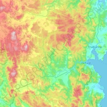
Name: Buckland topographic map, elevation, terrain.

Location: Buckland, Glamorgan-Spring Bay, Tasmania, Australia (-42.71454 147.58592 -42.33971 147.88738)

Average elevation: 271 m

Minimum elevation: -2 m

Maximum elevation: 808 m

Other topographic maps

Click on a map to view its topography, its elevation and its terrain.

Cathedral Mountain

Australia > Tasmania

Average elevation: 992 m

The Nut

Australia > Tasmania > Stanley

Average elevation: 8 m

Waterworks Reserve

Australia > Tasmania > Hobart

Average elevation: 240 m

Rowlands Hill

Australia > Tasmania

Average elevation: 388 m

Bream Creek

Australia > Tasmania > Bream Creek

Average elevation: 35 m

Cradle Mountain

Australia > Tasmania > Cradle Mountain

Average elevation: 1,144 m

West Gawler River

Australia > Tasmania > Sprent > Gawler

Average elevation: 201 m

Mount Patrick

Australia > Tasmania

Average elevation: 863 m

Mount Tyndall

Australia > Tasmania

Average elevation: 910 m

Mount Ossa

Australia > Tasmania

Average elevation: 1,218 m

Gear up for your next adventure:

🧢Outdoor Cap - Protective cap for sun and rain during hikes
🚲Handlebar Phone Mount - View topographic-map.com live while cycling
🧼Travel Hand Sanitizer - Keep hands clean when water is scarce
🦯Trekking Poles - Reduced impact on joints for steep topographic climbs
🔦LED Headlamp - Hands-free lighting for early morning starts or late finishes

As an Amazon Associate, this site earns from qualifying purchases at no extra cost to you.