
Make a donation
Gear up for your next adventure:
As an Amazon Associate, this site earns from qualifying purchases at no extra cost to you.
Crater Lake topographic map
Click on the map to display elevation.
Make a donation
Gear up for your next adventure:
As an Amazon Associate, this site earns from qualifying purchases at no extra cost to you.
Crater Lake
The lake is 5 by 6 miles (8.0 by 9.7 km) across, with a caldera rim ranging in elevation from 7,000 to 8,000 feet (2,100 to 2,400 m) and an average lake depth of 1,148 feet (350 m). The lake's maximum depth has been measured at 1,949 feet (594 m), which fluctuates slightly as the weather changes. On the basis of maximum depth, Crater Lake is the deepest lake in the United States, the second-deepest in North America (after Great Slave Lake in Canada), and the ninth-deepest lake in the world. Crater Lake is often cited as the seventh-deepest lake in the world, but this ranking excludes Lake Vostok in Antarctica, which is beneath about 13,000 feet (4,000 m) of ice, and the recent depth soundings of O'Higgins/San Martín Lake, which is along the border of Chile and Argentina.
Make a donation
Gear up for your next adventure:
As an Amazon Associate, this site earns from qualifying purchases at no extra cost to you.
About this map
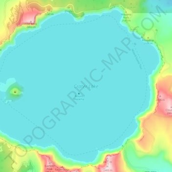
Name: Crater Lake topographic map, elevation, terrain.
Location: Crater Lake, Klamath County, Oregon, United States (42.90431 -122.16453 42.97874 -122.04998)
Average elevation: 1,971 m
Minimum elevation: 1,853 m
Maximum elevation: 2,483 m
Make a donation
Gear up for your next adventure:
As an Amazon Associate, this site earns from qualifying purchases at no extra cost to you.
Other topographic maps
Click on a map to view its topography, its elevation and its terrain.