
Make a donation
Gear up for your next adventure:
As an Amazon Associate, this site earns from qualifying purchases at no extra cost to you.
Gößnitz topographic map
Click on the map to display elevation.
Make a donation
Gear up for your next adventure:
As an Amazon Associate, this site earns from qualifying purchases at no extra cost to you.
About this map
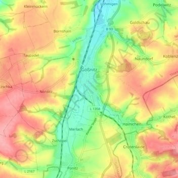
Name: Gößnitz topographic map, elevation, terrain.
Location: Gößnitz, Altenburger Land, Thüringen, 04639, Deutschland (50.86210 12.39611 50.90323 12.48819)
Average elevation: 248 m
Minimum elevation: 198 m
Maximum elevation: 292 m
Make a donation
Gear up for your next adventure:
As an Amazon Associate, this site earns from qualifying purchases at no extra cost to you.
Other topographic maps
Click on a map to view its topography, its elevation and its terrain.
Beerwalde
Deutschland > Thüringen > Altenburger Land
1968 kam die SDAG Wismut in das Umfeld von Ronneburg und in die eigene Gemarkung, wo in drei Schächten der Lagerstätte Drosen Uranerz abgebaut wurde. Die Industrialisierung begann unkontrollierbar für die Bewohner. Es folgten Betonstraßen, Förderanlagen und Belastungen für Mensch und Tier. Zwischen 1977…
Average elevation: 291 m
Steinsdorf
Deutschland > Thüringen > Altenburger Land > Schmölln > Burkersdorf
Average elevation: 255 m
Make a donation
Gear up for your next adventure:
As an Amazon Associate, this site earns from qualifying purchases at no extra cost to you.
Make a donation
Gear up for your next adventure:
As an Amazon Associate, this site earns from qualifying purchases at no extra cost to you.
Make a donation
Gear up for your next adventure:
As an Amazon Associate, this site earns from qualifying purchases at no extra cost to you.