
Make a donation
Gear up for your next adventure:
As an Amazon Associate, this site earns from qualifying purchases at no extra cost to you.
Nitzschka topographic map
Click on the map to display elevation.
Make a donation
Gear up for your next adventure:
As an Amazon Associate, this site earns from qualifying purchases at no extra cost to you.
About this map
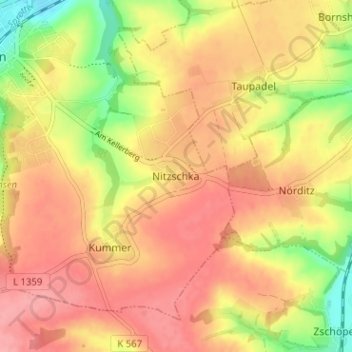
Name: Nitzschka topographic map, elevation, terrain.
Average elevation: 263 m
Minimum elevation: 206 m
Maximum elevation: 298 m
Make a donation
Gear up for your next adventure:
As an Amazon Associate, this site earns from qualifying purchases at no extra cost to you.
Other topographic maps
Click on a map to view its topography, its elevation and its terrain.
Nöbdenitz
Deutschland > Thüringen > Altenburger Land > Schmölln
Schräg gegenüber der Kirche befindet sich mit der Grabeiche eine mindestens 1200 Jahre alte Stieleiche. Unter ihren Wurzeln wurde wunschgemäß der Staatsminister des Herzogtums Sachsen-Gotha-Altenburg Hans Wilhelm von Thümmel nach seinem Tod im Jahr 1824 beigesetzt. Der Rittergutsbesitzer hatte den Baum…
Average elevation: 262 m