Geolocate

De Kalb topographic map

Click on the map to display elevation.

About this map

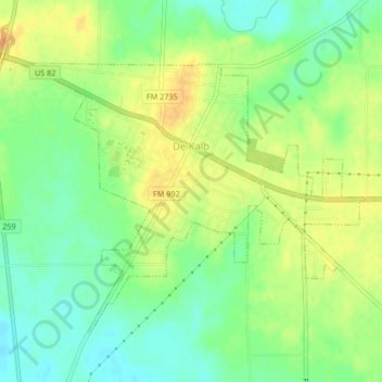
Name: De Kalb topographic map, elevation, terrain.

Location: De Kalb, Bowie County, Texas, 75559, United States (33.49158 -94.63902 33.51757 -94.59737)

Average elevation: 118 m

Minimum elevation: 102 m

Maximum elevation: 134 m

Other topographic maps

Click on a map to view its topography, its elevation and its terrain.

Old Salem

United States > Texas > Bowie County

Average elevation: 110 m

Eylau

United States > Texas > Bowie County

Average elevation: 93 m

Eylau

United States > Texas > Bowie County

Average elevation: 93 m

Gear up for your next adventure:

🦯Trekking Poles - Reduced impact on joints for steep topographic climbs
🧥Fleece Jacket - Warm and lightweight jacket for layering
Lightweight Backpacking Tent - Compact tent for efficient hiking trips
🧥Insulated Jacket - Keep warm in cold outdoor conditions
🧢Hiking Hat - Sun-protective and breathable hats for long treks

As an Amazon Associate, this site earns from qualifying purchases at no extra cost to you.