Geolocate

Lymore topographic map

Click on the map to display elevation.

About this map

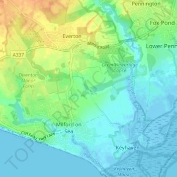
Name: Lymore topographic map, elevation, terrain.

Location: Lymore, Milford-on-Sea, Milford on Sea, New Forest, Hampshire, England, SO41 0TW, United Kingdom (50.71492 -1.60212 50.75492 -1.56212)

Average elevation: 11 m

Minimum elevation: -5 m

Maximum elevation: 34 m

Other topographic maps

Click on a map to view its topography, its elevation and its terrain.

Gear up for your next adventure:

Bushcraft Tarp - Versatile emergency shelter or gear protection
🥫Freeze-Dried Meals - Lightweight, high-calorie nutrition for multi-day treks
🧢Hiking Hat - Sun-protective and breathable hats for long treks
🧴Sunscreen SPF - Broad-spectrum sunscreen for outdoor activities
🔦LED Headlamp - Hands-free lighting for early morning starts or late finishes

As an Amazon Associate, this site earns from qualifying purchases at no extra cost to you.