Geolocate

Asenovgrad topographic map

Click on the map to display elevation.

About this map

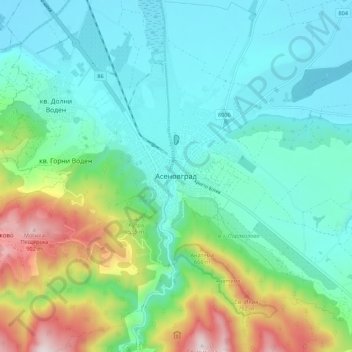
Name: Asenovgrad topographic map, elevation, terrain.

Location: Asenovgrad, Plovdiv, 4230, Bulgaria (41.96736 24.83627 42.04736 24.91627)

Average elevation: 372 m

Minimum elevation: 183 m

Maximum elevation: 945 m

Other topographic maps

Click on a map to view its topography, its elevation and its terrain.

Западен

Bulgaria > Plovdiv > Plovdiv

Average elevation: 172 m

Южен

Bulgaria > Plovdiv

Average elevation: 173 m

Източен

Bulgaria > Plovdiv

Average elevation: 159 m

Hisaria

Bulgaria > Plovdiv

Average elevation: 524 m

Южен

Bulgaria > Plovdiv

Average elevation: 173 m

Централен

Bulgaria > Plovdiv

Average elevation: 168 m

Gear up for your next adventure:

Tent Footprint - Protect tent floor and increase durability
🥾Lightweight Hiking Boots - Boots for comfort and mobility on long hikes
🕶️Polarized Sunglasses - Protect your eyes with durable polarized lenses
👟Sport Hiking Sandals - Breathable footwear for water crossings and camp rest
🎒Backpack Rain Cover - External shield to keep your entire pack dry

As an Amazon Associate, this site earns from qualifying purchases at no extra cost to you.