Geolocate

Eggedal topographic map

Click on the map to display elevation.

About this map

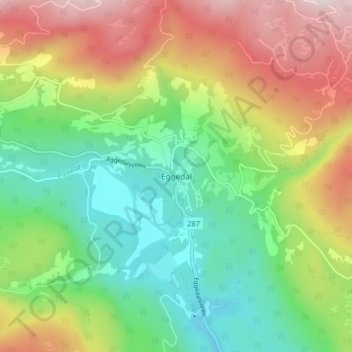
Name: Eggedal topographic map, elevation, terrain.

Location: Eggedal, Sigdal, Buskerud, 3359, Norway (60.22635 9.33649 60.26635 9.37649)

Average elevation: 482 m

Minimum elevation: 238 m

Maximum elevation: 858 m

Other topographic maps

Click on a map to view its topography, its elevation and its terrain.

Flå

Norway > Buskerud

Average elevation: 719 m

Hemsedal

Norway > Buskerud

Average elevation: 1,217 m

Kongsberg

Norway > Buskerud

Average elevation: 388 m

Hol

Norway > Buskerud

Average elevation: 1,204 m

Norefjell

Norway > Buskerud

Average elevation: 758 m

Hemsedal

Norway > Buskerud

Average elevation: 1,217 m

Ringerike

Norway > Buskerud

Average elevation: 443 m

Flesberg

Norway > Buskerud

Average elevation: 520 m

Ål

Norway > Buskerud

The Bergen Line, the rail line between Oslo and Bergen runs through Ål. Ål Station has an elevation of 436 meters (1,430 ft) and is the halfway station on the Bergen Line.

Average elevation: 1,023 m

Flesberg

Norway > Buskerud

Average elevation: 520 m

Hemsedal

Norway > Buskerud

Average elevation: 1,217 m

Hemsedal

Norway > Buskerud

Average elevation: 1,217 m

Hole

Norway > Buskerud

Average elevation: 266 m

Drammen

Norway > Buskerud

Average elevation: 209 m

Drammen

Norway > Buskerud

Average elevation: 209 m

Nesbyen

Norway > Buskerud

Average elevation: 842 m

Gear up for your next adventure:

👖Convertible Hiking Pants - Zip-off legs to adapt to changing weather conditions
👟Trail Running Shoes - Agile footwear for fast-paced topographic exploration
🛁Quick-Dry Microfiber Towel - Space-saving towel that dries rapidly on the move
🧦Outdoor Socks - Durable socks designed for hiking and outdoor sports
🧴Sunscreen SPF - Broad-spectrum sunscreen for outdoor activities

As an Amazon Associate, this site earns from qualifying purchases at no extra cost to you.