

El Marsa topographic map
Click on the map to display elevation.
About this map
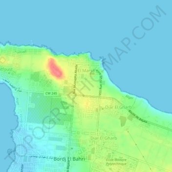
Name: El Marsa topographic map, elevation, terrain.
Location: El Marsa, Dar el-Beida District, Algiers, 16000, Algeria (36.79617 3.22297 36.81540 3.26796)
Average elevation: 14 m
Minimum elevation: -2 m
Maximum elevation: 67 m
Other topographic maps
Click on a map to view its topography, its elevation and its terrain.

El Hamiz
Algeria > Algiers > Dar el-Beida District > Burj Al Kifan > City BenZarga
Average elevation: 14 m


حي المجاهد طاهر غلاسه
Algeria > Algiers > Dar el-Beida District > Ain Taya > ديار الغرب
Average elevation: 22 m

Résidence Le Badr
Algeria > Algiers > Dar el-Beida District > Bordj El Bahri > Bordj el Bahri Faizi
Average elevation: 14 m

Résidence Le Badr
Algeria > Algiers > Dar el-Beida District > Bordj El Bahri > Cité 252 log
Average elevation: 14 m

The subdivision Mandariniers
Algeria > Algiers > Dar el-Beida District > Al Muhammadiyya > Pins Maritimes
Average elevation: 17 m

Bordj el Bahri Faizi
Algeria > Algiers > Dar el-Beida District > Bordj El Bahri
Average elevation: 19 m

Clos de car
Algeria > Algiers > Dar el-Beida District > Bordj El Bahri > Bordj el Bahri Faizi
Average elevation: 19 m
The subdivision Mandariniers
Algeria > Algiers > Dar el-Beida District > Al Muhammadiyya > Pins Maritimes
Average elevation: 17 m