Geolocate

Vicksburg topographic map

Click on the map to display elevation.

About this map

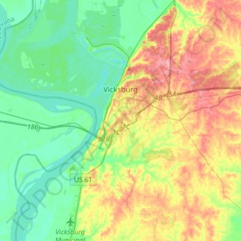
Name: Vicksburg topographic map, elevation, terrain.

Location: Vicksburg, Warren County, Mississippi, United States (32.22340 -90.95172 32.42808 -90.81890)

Average elevation: 51 m

Minimum elevation: 13 m

Maximum elevation: 119 m

Other topographic maps

Click on a map to view its topography, its elevation and its terrain.

Bovina

United States > Mississippi > Warren County

Average elevation: 65 m

Redwood

United States > Mississippi > Warren County

Average elevation: 48 m

Gear up for your next adventure:

🛶Waterproof Dry Bags - Keep electronics and clothes dry during river crossings
🔦LED Headlamp - Hands-free lighting for early morning starts or late finishes
🛏️Sleeping Bag - Warm and compact sleeping bags for outdoor camping
🧥Thermal Layer - Insulating layer for cold outdoor conditions
🥫Freeze-Dried Meals - Lightweight, high-calorie nutrition for multi-day treks

As an Amazon Associate, this site earns from qualifying purchases at no extra cost to you.