Geolocate

Sarreaus topographic map

Click on the map to display elevation.

About this map
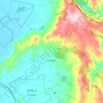
Name: Sarreaus topographic map, elevation, terrain.

Location: Sarreaus, Limia, Orense, Galicia, 32631, España (42.04029 -7.68475 42.15602 -7.55309)

Average elevation: 718 m

Minimum elevation: 614 m

Maximum elevation: 988 m

Other topographic maps

Click on a map to view its topography, its elevation and its terrain.

Forxa

España > Galicia > Limia > Porqueira

Average elevation: 703 m

Covelas

España > Galicia > Limia > Os Blancos

Average elevation: 735 m

Feás

España > Galicia > Limia

Average elevation: 1,013 m

Vilar de Covelas

España > Galicia > Limia > Os Blancos

Average elevation: 768 m

Paradiña

España > Galicia > Limia > Sarreaus

Average elevation: 875 m

Vilariño Frío

España > Galicia > Limia > Sarreaus

Average elevation: 824 m

Garabelos

España > Galicia > Limia > Baltar

Average elevation: 776 m

Faramontaos

España > Galicia > Limia > Xinzo de Limia

Average elevation: 679 m

Guillamil

España > Galicia > Limia > Rairiz de Veiga

Average elevation: 721 m

Guntimil

España > Galicia > Limia > Xinzo de Limia

Average elevation: 706 m

Guillamil

España > Galicia > Limia > Rairiz de Veiga

Average elevation: 721 m

Gear up for your next adventure:

🎒Backpack Rain Cover - External shield to keep your entire pack dry
🦶Anti-Blister Balm - Prevents friction and hotspots during long ascents
🛁Quick-Dry Microfiber Towel - Space-saving towel that dries rapidly on the move
🧥Softshell Jacket - Windproof and breathable jacket for hiking
🧤Insulated Winter Gloves - Heavy-duty protection for sub-zero Canadian adventures

As an Amazon Associate, this site earns from qualifying purchases at no extra cost to you.