Geolocate

Orsa topographic map

Click on the map to display elevation.

About this map

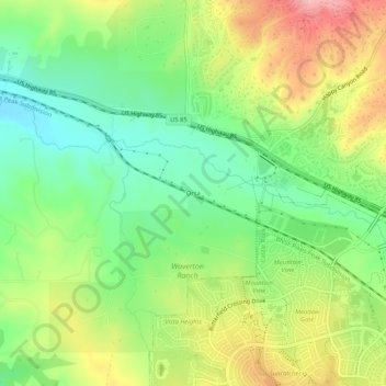
Name: Orsa topographic map, elevation, terrain.

Location: Orsa, Douglas County, Colorado, 80109, United States (39.40234 -104.93384 39.44234 -104.89384)

Average elevation: 1,846 m

Minimum elevation: 1,781 m

Maximum elevation: 1,936 m

Other topographic maps

Click on a map to view its topography, its elevation and its terrain.

Perry Park

United States > Colorado > Douglas County

Average elevation: 2,077 m

The Pinery

United States > Colorado > Douglas County > Castle Rock

Average elevation: 1,897 m

Four Square Park

United States > Colorado > Douglas County

Average elevation: 1,823 m

Russelville Gulch

United States > Colorado > Douglas County

Average elevation: 1,891 m

Larkspur

United States > Colorado > Douglas County

Average elevation: 2,102 m

Gear up for your next adventure:

🧥Insulated Jacket - Keep warm in cold outdoor conditions
🔨Vehicle Emergency Tool - Safety tool for remote road trips to trailheads
🧰Multitool Knife - Compact and versatile tool for outdoor use
🧥Fleece Jacket - Warm and lightweight jacket for layering
🧴Insect Repellent - Protect yourself from bugs during outdoor adventures

As an Amazon Associate, this site earns from qualifying purchases at no extra cost to you.