
Make a donation
Gear up for your next adventure:
As an Amazon Associate, this site earns from qualifying purchases at no extra cost to you.
Salineville topographic map
Click on the map to display elevation.
Make a donation
Gear up for your next adventure:
As an Amazon Associate, this site earns from qualifying purchases at no extra cost to you.
About this map
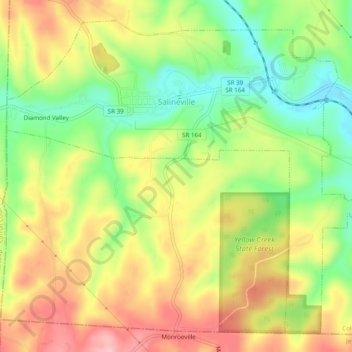
Name: Salineville topographic map, elevation, terrain.
Location: Salineville, Columbiana County, Ohio, 43945, United States (40.59831 -80.86142 40.63108 -80.81270)
Average elevation: 335 m
Minimum elevation: 259 m
Maximum elevation: 414 m
Make a donation
Gear up for your next adventure:
As an Amazon Associate, this site earns from qualifying purchases at no extra cost to you.
Other topographic maps
Click on a map to view its topography, its elevation and its terrain.
Make a donation
Gear up for your next adventure:
As an Amazon Associate, this site earns from qualifying purchases at no extra cost to you.
Highlandtown Lake Dam
United States > Ohio > Columbiana County > Highlandtown
Average elevation: 344 m
Make a donation
Gear up for your next adventure:
As an Amazon Associate, this site earns from qualifying purchases at no extra cost to you.