Geolocate

Big Rock topographic map

Click on the map to display elevation.

About this map

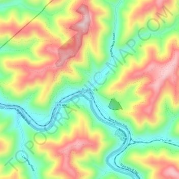
Name: Big Rock topographic map, elevation, terrain.

Location: Big Rock, Buchanan County, Virginia, 24603, United States (37.33646 -82.20931 37.37646 -82.16931)

Average elevation: 423 m

Minimum elevation: 259 m

Maximum elevation: 614 m

Other topographic maps

Click on a map to view its topography, its elevation and its terrain.

Vansant

United States > Virginia > Buchanan County

Average elevation: 547 m

Gear up for your next adventure:

🎒Hiking Daypack - Lightweight and durable backpacks for day trips and excursions
🧭GPS Outdoor Watch - Smart watch for navigation and fitness tracking in nature
👖Convertible Hiking Pants - Zip-off legs to adapt to changing weather conditions
🎒Fully Waterproof Backpack - Total protection for photography gear and electronics
🪜Heavy Duty Carabiners - Multi-use clips for securing gear to your backpack

As an Amazon Associate, this site earns from qualifying purchases at no extra cost to you.