Geolocate

Peebles topographic map

Click on the map to display elevation.

About this map

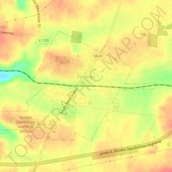
Name: Peebles topographic map, elevation, terrain.

Location: Peebles, Meigs Township, Adams County, Ohio, United States (38.93782 -83.42806 38.95821 -83.39492)

Average elevation: 253 m

Minimum elevation: 217 m

Maximum elevation: 268 m

Other topographic maps

Click on a map to view its topography, its elevation and its terrain.

Louden

United States > Ohio > Adams County

Average elevation: 242 m

Ohio Brush Creek

United States > Ohio > Adams County

Average elevation: 272 m

Tranquility

United States > Ohio > Adams County

Average elevation: 255 m

Whippoorwill

United States > Ohio > Adams County > Whippoorwill

Average elevation: 245 m

Gear up for your next adventure:

🪑Ultralight Camping Stool - Compact seating for rest stops during long hikes
🧤Thermal Hiking Gloves - Grip-enhanced gloves for cold-weather altitude trekking
🌡️Emergency Mylar Blankets - Compact thermal protection for unexpected nights outdoors
🧦Thermal Socks - Warm socks for winter hiking or camping
💧Hydration Bladder - Hands-free hydration solution for long treks

As an Amazon Associate, this site earns from qualifying purchases at no extra cost to you.