Geolocate

Louden topographic map

Click on the map to display elevation.

About this map

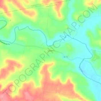
Name: Louden topographic map, elevation, terrain.

Location: Louden, Bratton Township, Adams County, Ohio, United States (39.00674 -83.47269 39.04674 -83.43269)

Average elevation: 242 m

Minimum elevation: 199 m

Maximum elevation: 299 m

Other topographic maps

Click on a map to view its topography, its elevation and its terrain.

Peebles

United States > Ohio > Adams County

Average elevation: 253 m

Meigs Township

United States > Ohio > Adams County

Average elevation: 256 m

Rome

United States > Ohio > Adams County

Average elevation: 186 m

Bratton Township

United States > Ohio > Adams County

Average elevation: 247 m

Ohio Brush Creek

United States > Ohio > Adams County

Average elevation: 272 m

Manchester

United States > Ohio > Adams County

Average elevation: 191 m

Peebles

United States > Ohio > Adams County

Average elevation: 253 m

Gear up for your next adventure:

🧴Bear Spray Holster - Quick-access carry for essential Canadian wilderness safety
🥾Waterproof Hiking Shoes - Durable shoes for wet and rugged trails
🥾Hiking Boots - Sturdy boots providing ankle support and traction on rugged trails
🧦Thermal Socks - Warm socks for winter hiking or camping
🧢Hiking Hat - Sun-protective and breathable hats for long treks

As an Amazon Associate, this site earns from qualifying purchases at no extra cost to you.