Geolocate

Bowman topographic map

Click on the map to display elevation.

About this map

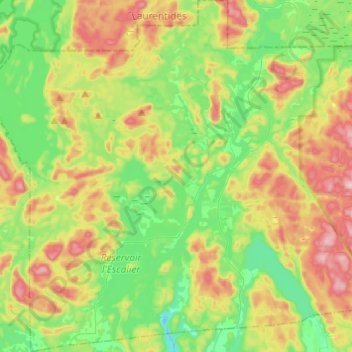
Name: Bowman topographic map, elevation, terrain.

Location: Bowman, Papineau, Outaouais, Quebec, Canada (45.82500 -75.77725 45.99442 -75.57336)

Average elevation: 254 m

Minimum elevation: 131 m

Maximum elevation: 461 m

Papineau trails, hiking, mountain biking, running and outdoor activities

Other topographic maps

Click on a map to view its topography, its elevation and its terrain.

Chutes Lockbow

Canada > Quebec > Papineau > Chénéville

Average elevation: 229 m

Vernet

Canada > Quebec > Papineau > Boileau

Average elevation: 221 m

Lac Frappier

Canada > Quebec > Papineau > Duhamel

Average elevation: 289 m

Lac Cameron

Canada > Quebec > Papineau > Val-des-Bois

Average elevation: 349 m

Gear up for your next adventure:

🥾Trekking Boots - Durable boots for long-distance trekking
Camping Groundsheet - Protect your tent from moisture and dirt
🔦LED Headlamp - Hands-free lighting for early morning starts or late finishes
Lightweight Backpacking Tent - Compact tent for efficient hiking trips
🐕Hiking Dog Pack - Let your canine companion carry their own water and food

As an Amazon Associate, this site earns from qualifying purchases at no extra cost to you.