Geolocate

Valley City topographic map

Click on the map to display elevation.

About this map

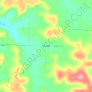
Name: Valley City topographic map, elevation, terrain.

Location: Valley City, Harrison County, Indiana, 47110, United States (38.07396 -86.24275 38.11396 -86.20275)

Average elevation: 199 m

Minimum elevation: 147 m

Maximum elevation: 273 m

Other topographic maps

Click on a map to view its topography, its elevation and its terrain.

Lanesville

United States > Indiana > Harrison County

Average elevation: 239 m

New Amsterdam

United States > Indiana > Harrison County

Average elevation: 151 m

New Middletown

United States > Indiana > Harrison County

Average elevation: 215 m

Crandall

United States > Indiana > Harrison County

Average elevation: 217 m

Laconia

United States > Indiana > Harrison County

Average elevation: 201 m

Gear up for your next adventure:

🎒Fully Waterproof Backpack - Total protection for photography gear and electronics
🧢Outdoor Visor - Breathable visor for sunny hikes
💧Hydration Pack - Hands-free hydration system for long hikes
🪑Insulated Seat Pad - Protect your seat from cold rocks and wet logs
🔭Compact Binoculars - Lightweight optics for scouting trails and wildlife

As an Amazon Associate, this site earns from qualifying purchases at no extra cost to you.