Geolocate

Florence topographic map

Click on the map to display elevation.

About this map

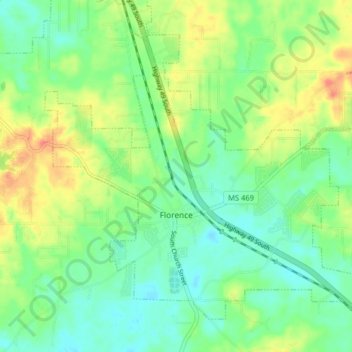
Name: Florence topographic map, elevation, terrain.

Location: Florence, Rankin County, Mississippi, 39073, United States (32.13308 -90.16113 32.18897 -90.08109)

Average elevation: 102 m

Minimum elevation: 81 m

Maximum elevation: 136 m

Other topographic maps

Click on a map to view its topography, its elevation and its terrain.

Johns

United States > Mississippi > Rankin County

Average elevation: 118 m

Value

United States > Mississippi > Rankin County > Brandon

Average elevation: 125 m

Lakeland

United States > Mississippi > Rankin County > Richland

Average elevation: 90 m

Leesburg

United States > Mississippi > Rankin County

Average elevation: 112 m

Cleary

United States > Mississippi > Rankin County

Average elevation: 103 m

Lakeshore

United States > Mississippi > Rankin County

Average elevation: 92 m

Plainview

United States > Mississippi > Rankin County > Richland

Average elevation: 96 m

Sinai

United States > Mississippi > Rankin County

Average elevation: 89 m

Gear up for your next adventure:

🧭Orienteering Kit - Tools for map reading and navigation in the wild
🥾Lightweight Hiking Shoes - Comfortable shoes for day hikes
🔋Solar Power Bank - Keep your GPS and devices charged during long outdoor trips
🥾Trekking Poles - Adjustable trekking poles to reduce knee stress and improve stability
🧥Thermal Fleece Jacket - Versatile insulation for changing mountain temperatures

As an Amazon Associate, this site earns from qualifying purchases at no extra cost to you.