Geolocate

Coco Islands topographic map

Click on the map to display elevation.

About this map

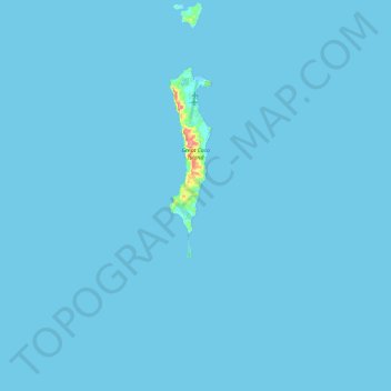
Name: Coco Islands topographic map, elevation, terrain.

Location: Coco Islands, Cocokyun, Thanlyin District, Yangon, Myanmar (13.97131 93.21859 14.19306 93.38267)

Average elevation: 1 m

Minimum elevation: 0 m

Maximum elevation: 79 m

Other topographic maps

Click on a map to view its topography, its elevation and its terrain.

Thanlyin

Myanmar > Yangon > Thanlyin District

Average elevation: 6 m

Phagu

Myanmar > Yangon > Thanlyin District

Average elevation: 4 m

Gear up for your next adventure:

🧢Hiking Sun Hat - Wide-brimmed protection for exposed mountain ridges
Backpacking Tent - Lightweight tent for long-distance hiking trips
🥾Waterproof Hiking Shoes - Durable shoes for wet and rugged trails
🔋Solar Power Bank - Keep your GPS and devices charged during long outdoor trips
🚲Bike Repair Kit - Essential tools for on-trail mechanical issues

As an Amazon Associate, this site earns from qualifying purchases at no extra cost to you.