Geolocate

Mancha Real topographic map

Click on the map to display elevation.

About this map

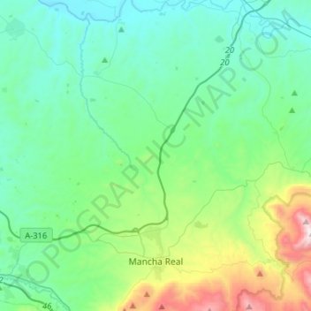
Name: Mancha Real topographic map, elevation, terrain.

Location: Mancha Real, Jaén, Andalusia, Spain (37.75392 -3.66909 37.95806 -3.56853)

Average elevation: 552 m

Minimum elevation: 246 m

Maximum elevation: 1,742 m

Other topographic maps

Click on a map to view its topography, its elevation and its terrain.

Bel-Air

Spain > Andalusia > Costa del Sol Occidental > Estepona

Average elevation: 35 m

Rícmar

Spain > Andalusia > Costa del Sol Occidental > Marbella

Average elevation: 35 m

Mondrón

Spain > Andalusia > La Axarquía > Periana

Average elevation: 576 m

Gear up for your next adventure:

🧼Biodegradable Camp Soap - Environmentally friendly cleaning for gear and body
🧶550 Survival Paracord - Versatile utility cord for emergency repairs and rigging
🧢Hiking Hat - Sun-protective and breathable hats for long treks
🚑Survival Whistle - Signal for help across long distances in mountains
Camping Tent - Weather-resistant tents suitable for 2 to 6 people

As an Amazon Associate, this site earns from qualifying purchases at no extra cost to you.