Geolocate

Koppom topographic map

Click on the map to display elevation.

About this map

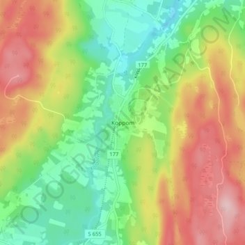
Name: Koppom topographic map, elevation, terrain.

Location: Koppom, Eda kommun, Värmland County, 670 41, Sweden (59.68316 12.12946 59.72316 12.16946)

Average elevation: 183 m

Minimum elevation: 98 m

Maximum elevation: 290 m

Other topographic maps

Click on a map to view its topography, its elevation and its terrain.

Sunne kommun

Sweden > Värmland County

Average elevation: 194 m

Hammarö kommun

Sweden > Värmland County

Average elevation: 45 m

Hammarö kommun

Sweden > Värmland County

Average elevation: 45 m

Hagfors kommun

Sweden > Värmland County

Average elevation: 257 m

Kils kommun

Sweden > Värmland County

Average elevation: 104 m

Torsby kommun

Sweden > Värmland County

Average elevation: 356 m

Pottern

Sweden > Värmland County

Average elevation: 145 m

Säffle kommun

Sweden > Värmland County

Average elevation: 89 m

Karlstads kommun

Sweden > Värmland County

Average elevation: 109 m

Filipstads kommun

Sweden > Värmland County

Average elevation: 241 m

Storfors kommun

Sweden > Värmland County

Average elevation: 158 m

Gear up for your next adventure:

🎒Hiking Backpack - Lightweight and ergonomic backpacks for day hikes or multi-day treks
🧢Outdoor Cap - Protective cap for sun and rain during hikes
🧥Waterproof Hiking Jacket - Protect yourself from rain and wind while hiking
🌡️Emergency Mylar Blankets - Compact thermal protection for unexpected nights outdoors
💧Hydration Pack - Hands-free hydration system for long hikes

As an Amazon Associate, this site earns from qualifying purchases at no extra cost to you.