Geolocate

Cuyapo topographic map

Click on the map to display elevation.

About this map

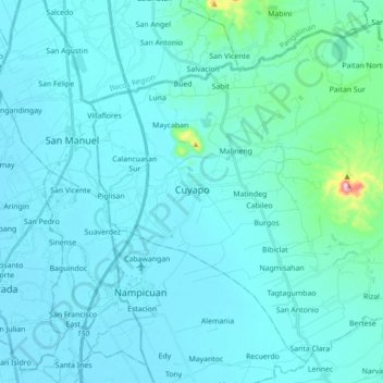
Name: Cuyapo topographic map, elevation, terrain.

Location: Cuyapo, Nueva Ecija, Central Luzon, 3117, Philippines (15.70166 120.61507 15.85131 120.79044)

Average elevation: 41 m

Minimum elevation: 14 m

Maximum elevation: 369 m

Other topographic maps

Click on a map to view its topography, its elevation and its terrain.

Cabanatuan

Philippines > Nueva Ecija

Average elevation: 47 m

Dulong Bayan

Philippines > Nueva Ecija > Quezon

Average elevation: 26 m

San Felipe

Philippines > Nueva Ecija

Average elevation: 125 m

Malasin

Philippines > Nueva Ecija > San Jose

Average elevation: 122 m

Pantabangan Dam

Philippines > Nueva Ecija > Pantabangan > Fatima

The dam is a 107 m (351 ft) tall and 1,615 m (5,299 ft) long embankment-type with 12,000,000 cu yd (9,174,658 m3) of homogeneous earth-fill and an impervious core. The crest of the dam is 12 m (39 ft) wide while the widest part of its base is 535 m (1,755 ft). The dam's crest sits at an elevation of 232 m (761…

Average elevation: 210 m

Cecilia Village

Philippines > Nueva Ecija > Cabanatuan

Average elevation: 32 m

Pangatian

Philippines > Nueva Ecija

Average elevation: 49 m

San Isidro

Philippines > Nueva Ecija

Average elevation: 19 m

Peñaranda

Philippines > Nueva Ecija

Average elevation: 38 m

Palayan

Philippines > Nueva Ecija

Average elevation: 126 m

Calaanan

Philippines > Nueva Ecija

Average elevation: 219 m

Llanera

Philippines > Nueva Ecija

Average elevation: 70 m

Gabaldon

Philippines > Nueva Ecija

Average elevation: 308 m

San Agustin

Philippines > Nueva Ecija

Average elevation: 41 m

San Antonio

Philippines > Nueva Ecija

Average elevation: 15 m

Muñoz

Philippines > Nueva Ecija

Situated 152 kilometres (94 mi) north of the capital Manila and due to its rich topography and tropical climate, it is now home to agricultural research and technology centers, committed to the production of information and technological breakthroughs to promote rural development, productivity and food…

Average elevation: 86 m

Umangan

Philippines > Nueva Ecija > Umangan

Average elevation: 32 m

Bagong Silang

Philippines > Nueva Ecija > Bagong Silang

Average elevation: 12 m

Kalikid Norte

Philippines > Nueva Ecija > Cabanatuan

Average elevation: 59 m

Santa Rosa

Philippines > Nueva Ecija > Santa Rosa

Average elevation: 27 m

Carranglan

Philippines > Nueva Ecija > Carranglan

Average elevation: 296 m

Talavera

Philippines > Nueva Ecija

Average elevation: 41 m

Lomboy

Philippines > Nueva Ecija > Lomboy

Average elevation: 46 m

General Tinio

Philippines > Nueva Ecija

Farming is the livelihood of majority of the residents. Even though located at the foot of the Sierra Madre Mountain Ridges, the topography is generally plain ideal to agricultural products such as palay and vegetables. A number of poultry broiler contract growers are located in the municipality. Other…

Average elevation: 54 m

Lawang Kupang

Philippines > Nueva Ecija

Average elevation: 16 m

Lupao

Philippines > Nueva Ecija

Lupao belongs to the first type of climate in the Philippines. This type of climate has two (2) pronounced seasons: dry from the month of November to April and Wet during the rest of the year. This type of climate is typically hot, humid and tropical and is generally affected by the neighboring topography and…

Average elevation: 163 m

Ciudad de Real

Philippines > Nueva Ecija > Cabanatuan

Average elevation: 36 m

Gear up for your next adventure:

🏃Hydration Running Vest - Carry water and maps close to your body for speed
💧Collapsible Water Bottle - Space-saving water bottle for outdoor activities
💧Filtered Water Bottle - Safe drinking water on the go
🎒Hiking Daypack - Lightweight and durable backpacks for day trips and excursions
🥾Hiking Gaiters - Protect legs and shoes from mud, snow, and debris

As an Amazon Associate, this site earns from qualifying purchases at no extra cost to you.