Geolocate

Karbo topographic map

Click on the map to display elevation.

About this map

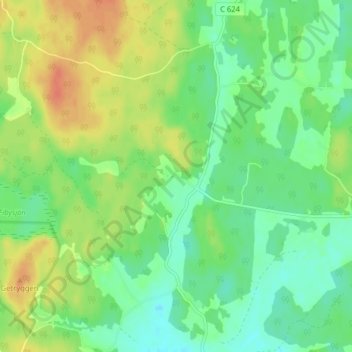
Name: Karbo topographic map, elevation, terrain.

Location: Karbo, Uppsala kommun, Uppsala County, 740 20, Sweden (59.87917 17.36586 59.91917 17.40586)

Average elevation: 41 m

Minimum elevation: 24 m

Maximum elevation: 65 m

Other topographic maps

Click on a map to view its topography, its elevation and its terrain.

Hanelundssjön

Sweden > Uppsala County > Risbergsbo

Average elevation: 68 m

Älvkarleby kommun

Sweden > Uppsala County

Average elevation: 20 m

Östhammars kommun

Sweden > Uppsala County

Average elevation: 10 m

Knivsta kommun

Sweden > Uppsala County

Average elevation: 25 m

Enköpings kommun

Sweden > Uppsala County

Average elevation: 24 m

Uppsala kommun

Sweden > Uppsala County

Average elevation: 36 m

Hargshamn

Sweden > Uppsala County

Average elevation: 5 m

Heby kommun

Sweden > Uppsala County

Average elevation: 61 m

Gear up for your next adventure:

🥘Camping Cookware Set - Compact nesting pots and pans for trail cooking
🎒Fully Waterproof Backpack - Total protection for photography gear and electronics
🧼Travel Hand Sanitizer - Keep hands clean when water is scarce
🔥Emergency Fire Starter - Reliable ignition source for all weather conditions
🪑Insulated Seat Pad - Protect your seat from cold rocks and wet logs

As an Amazon Associate, this site earns from qualifying purchases at no extra cost to you.