Geolocate

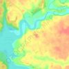
Moscow topographic map

Click on the map to display elevation.

About this map
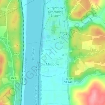
Name: Moscow topographic map, elevation, terrain.

Location: Moscow, Washington Township, Clermont County, Ohio, United States (38.85433 -84.23363 38.86665 -84.21952)

Average elevation: 177 m

Minimum elevation: 141 m

Maximum elevation: 255 m

Other topographic maps

Click on a map to view its topography, its elevation and its terrain.
Perintown

United States > Ohio > Clermont County

Average elevation: 199 m

Cedron

United States > Ohio > Clermont County

Average elevation: 228 m

The Highlands

United States > Ohio > Clermont County

Average elevation: 218 m

Amelia

United States > Ohio > Clermont County

Average elevation: 265 m

Sundale

United States > Ohio > Clermont County

Average elevation: 229 m

Concord

United States > Ohio > Clermont County

Average elevation: 253 m

The Highlands

United States > Ohio > Clermont County

Average elevation: 218 m

Hills

United States > Ohio > Clermont County

Average elevation: 243 m

Laurel

United States > Ohio > Clermont County

Average elevation: 252 m

The Highlands

United States > Ohio > Clermont County

Average elevation: 218 m

Saltair

United States > Ohio > Clermont County

Average elevation: 268 m

The Highlands

United States > Ohio > Clermont County

Average elevation: 218 m

Gear up for your next adventure:

🧰Multitool Knife - Compact and versatile tool for outdoor use
⛺Backpacking Tent - Lightweight tent for long-distance hiking trips
💧Filtered Water Bottle - Safe drinking water on the go
🛏️Camping Sleeping Mat - Comfortable mats for sleeping outdoors
🔦LED Headtorch - Bright and durable light for night activities

As an Amazon Associate, this site earns from qualifying purchases at no extra cost to you.