Geolocate

Petrinja topographic map

Click on the map to display elevation.

About this map

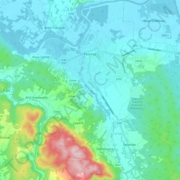
Name: Petrinja topographic map, elevation, terrain.

Location: Petrinja, Town of Petrinja, Sisak-Moslavina County, 44250, Croatia (45.38460 16.25102 45.46559 16.36633)

Average elevation: 154 m

Minimum elevation: 93 m

Maximum elevation: 411 m

Other topographic maps

Click on a map to view its topography, its elevation and its terrain.

Paklenica

Croatia > Sisak-Moslavina County > Grad Novska

Average elevation: 133 m

Bobovac

Croatia > Sisak-Moslavina County

Average elevation: 94 m

Matijevići

Croatia > Sisak-Moslavina County

Average elevation: 168 m

Maja

Croatia > Sisak-Moslavina County > Town of Glina

Average elevation: 156 m

Gear up for your next adventure:

🔋Solar Power Bank - Keep your GPS and devices charged during long outdoor trips
🧳Compression Sacks - Maximize space in your backpack by shrinking gear
🧰Emergency Multi-Tool - Compact multi-tool for outdoor survival
👟Sport Hiking Sandals - Breathable footwear for water crossings and camp rest
🧣Merino Neck Gaiter - Protects against wind, sun, and cold at high altitudes

As an Amazon Associate, this site earns from qualifying purchases at no extra cost to you.