Geolocate

Saulnierville topographic map

Click on the map to display elevation.

About this map
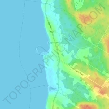
Name: Saulnierville topographic map, elevation, terrain.

Location: Saulnierville, Clare Municipal District, Digby County, Nova Scotia, B0W 2Z0, Canada (44.24463 -66.14663 44.27954 -66.10291)

Average elevation: 10 m

Minimum elevation: -1 m

Maximum elevation: 44 m

Digby County trails, hiking, mountain biking, running and outdoor activities

Other topographic maps

Click on a map to view its topography, its elevation and its terrain.
Lighthouse Road

Canada > Nova Scotia > Digby County > Bay View

Average elevation: 44 m

Snare Lake

Canada > Nova Scotia > Digby County > Hectanooga

Average elevation: 65 m

Digby Neck

Canada > Nova Scotia > Digby County > Lake Midway

Average elevation: 58 m

Tobacco Lake

Canada > Nova Scotia > Digby County > Morganville

Average elevation: 143 m

Gear up for your next adventure:

🔭Outdoor Binoculars - Lightweight binoculars for birdwatching and hiking
💡Compact LED Flashlight - Powerful and portable flashlight for outdoor use
🗺️Topographic Maps - Detailed maps to explore trails, mountains, and wilderness areas
🔦UV Flashlight - Detect minerals or specific insects in the dark
🥘Camping Cookware Set - Compact nesting pots and pans for trail cooking

As an Amazon Associate, this site earns from qualifying purchases at no extra cost to you.