Geolocate

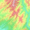
Bansra Gali topographic map

Click on the map to display elevation.

About this map

Name: Bansra Gali topographic map, elevation, terrain.

Location: Bansra Gali, Murree Tehsil, Murree District, Rawalpindi Division, Punjab, Pakistan (33.88456 73.35098 33.92456 73.39098)

Average elevation: 1,709 m

Minimum elevation: 1,181 m

Maximum elevation: 2,190 m

Other topographic maps

Click on a map to view its topography, its elevation and its terrain.
Kotli Sattian Tehsil

Pakistan > Punjab > Murree District

Average elevation: 1,213 m

Murree Tehsil

Pakistan > Punjab > Murree District

Average elevation: 1,278 m

Murree Tehsil

Pakistan > Punjab > Murree District

Average elevation: 1,278 m

Gear up for your next adventure:

👖Convertible Hiking Pants - Zip-off legs to adapt to changing weather conditions
🧴Sunscreen SPF - Broad-spectrum sunscreen for outdoor activities
💡LED Headlamp - Hands-free illumination for night hiking and camping
🧭Orienteering Kit - Tools for map reading and navigation in the wild
🛶Canoe Life Vest - Safety vest for water sports

As an Amazon Associate, this site earns from qualifying purchases at no extra cost to you.