Geolocate

Söderala topographic map

Click on the map to display elevation.

About this map

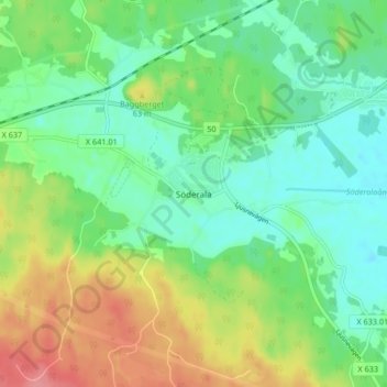
Name: Söderala topographic map, elevation, terrain.

Location: Söderala, Söderhamns kommun, Gävleborg County, 826 61, Sweden (61.25953 16.94404 61.29953 16.98404)

Average elevation: 38 m

Minimum elevation: 9 m

Maximum elevation: 90 m

Other topographic maps

Click on a map to view its topography, its elevation and its terrain.

Gran

Sweden > Gävleborg County > Gnarp District

Average elevation: 0 m

Ljusdals kommun

Sweden > Gävleborg County

Average elevation: 315 m

Disan

Sweden > Gävleborg County

Average elevation: 43 m

Hamra

Sweden > Gävleborg County

Average elevation: 437 m

Hamra

Sweden > Gävleborg County

Average elevation: 437 m

Hamra

Sweden > Gävleborg County

Average elevation: 437 m

Söderhamns kommun

Sweden > Gävleborg County

Average elevation: 67 m

Gnarp District

Sweden > Gävleborg County

Average elevation: 32 m

Hudiksvalls kommun

Sweden > Gävleborg County

Average elevation: 95 m

Gävle kommun

Sweden > Gävleborg County

Average elevation: 61 m

Gävle

Sweden > Gävleborg County

Average elevation: 28 m

Ovanåkers kommun

Sweden > Gävleborg County

Average elevation: 269 m

Hofors kommun

Sweden > Gävleborg County

Average elevation: 147 m

Gear up for your next adventure:

🥾Waterproof Hiking Shoes - Durable shoes for wet and rugged trails
🔋Solar Power Bank - Keep your GPS and devices charged during long outdoor trips
🌡️Emergency Mylar Blankets - Compact thermal protection for unexpected nights outdoors
🛏️Sleeping Bag - Warm and compact sleeping bags for outdoor camping
🧥Packable Rain Jacket - Breathable waterproof layer for unpredictable weather

As an Amazon Associate, this site earns from qualifying purchases at no extra cost to you.